

Ag Weather Forum
Flood Risk Update Sees Limited US Barge Transport Threats for Spring

Following a dose of winterlike conditions during the first half of March, the weather pattern is turning warmer, ushering in more of a spring feel. Part of that seasonal change is more activity along the U.S. river shipping network. That brings up the question of the flood threat for the spring 2022 season, as flooding can hinder or halt barge traffic and thus delay the movement of commodities, including fertilizer and grain.
For this spring, the flood risk is, in general, fairly low. That's true even in the Lower Mississippi River system, which had more precipitation during the winter than occurred in segments of the network further north.
The American Commercial Barge Line (ACBL) did note some flowing in the Lower Mississippi and along the Gulf of Mexico Coast as of March 14. An update by the ACBL detailed that the Lower Mississippi has been in high water since early February, forcing a cutback in tow sizes by from 12 to 16%, and some southbound vessels forced to stop overnight at terminals in Memphis, Tennessee and Vicksburg, Mississippi.
The Mississippi at Baton Rouge, Louisiana reached 30 feet on March 5 and forced some tow restrictions to meet U.S. Coast Guard flood regulations. The Mississippi was forecast to crest at Baton Rouge March 18 at just below 34 feet and then begin a slow fall.
The Mississippi gauge at New Orleans gauge reached 12 feet on March 8, enacting some restrictions. The Mississippi at New Orleans is expected to crest March 21 at 13 feet.
P[L1] D[0x0] M[300x250] OOP[F] ADUNIT[] T[]
Further northeast, the precipitation has been heavier in the Ohio, Tennessee and Cumberland River basins, which will bring about some delays to transit and fleet operations during the rest of March because of changes in river levels. The six- to 10-day forecast has somewhat less total precipitation in these basins, which offers the prospect of a decline to a normal pool during the next few weeks. This will be closely watched.
The ACBL post also notes that forecast precipitation in the Upper Mississippi and the Missouri River basins to see if the crest predictions hold.
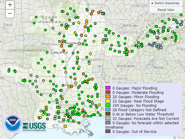
In contrast to conditions in some recent years, the U.S. Geological Survey flood assessment as of mid-March showed little to no flooding in the Lower Mississippi basin, and no flooding in the Upper Mississippi basin. With some phase of dryness or drought in effect in the Upper Mississippi basin, the lack of flooding is likely to be expected.
Some details in the final spring flood outlook issued by the St. Paul, Minnesota National Weather Service office on March 10 carried an optimistic tone as well. "The latest spring flood outlook for the Twin Cities service area is still average/normal," the report noted. "Nearly every spring flood parameter is near what we'd expect ... The headwaters of the Mississippi have a robust snowpack, but there is also plenty of room to intercept runoff due to the recent drought."
More river information is available at the following:
Memphis, Tennessee Hydrograph at https://water.weather.gov/…
Vicksburg, Mississippi Hydrograph at https://water.weather.gov/…
Baton Rouge, Louisiana Hydrograph at https://water.weather.gov/…
Bryce Anderson can be reached at Bryce.anderson@dtn.com
Follow him on Twitter @BAndersonDTN
(c) Copyright 2022 DTN, LLC. All rights reserved.
Comments
To comment, please Log In or Join our Community .