

Ag Weather Forum
Spring Warmth and Precipitation for Next 10 Days
The reign of the Arctic weather appears to be over. Low temperatures well-below the freezing mark followed a strong cold front through March 13, but that has quickly been replaced by above-normal temperatures across the majority of the country early this week.
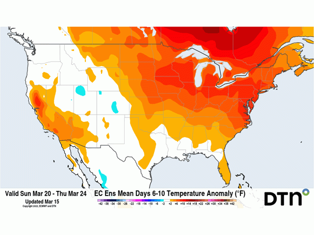
In fact, the forecast through March 24 calls for above-normal temperatures from the European model for everywhere except in the West and the Central and Southern Plains, which will have just brief shots of slightly below-normal air temperatures behind a couple of systems.
In the upper reaches of the troposphere, we are seeing the polar vortex take an interesting path. It is pinwheeling up through northeastern Canada and Greenland and will cross the North Pole this weekend before diving down on the other side of the world across Siberia next week. That is leaving a larger ridge pattern across North America, allowing for the springtime warmup.
But the absence of the polar vortex does not mean that the weather pattern will be quiet. The ridge is much too broad to have a dominant influence and so we will see disturbances and troughs move across the continent with some regularity.
P[L1] D[0x0] M[300x250] OOP[F] ADUNIT[] T[]
Currently, there is one such disturbance working across the Southeast U.S. It started to bring scattered showers and thunderstorms to eastern Oklahoma and Texas March 14 and will continue to trek eastward through March 17 before moving offshore. Moderate to locally heavy rainfall and bits of severe storms are expected. Drought reduction is likely for many of these areas.
Another trough will move into the West March 16 in a couple of pieces and then move from the Southern Plains up the Ohio River March 17-19. This system could produce some good precipitation in eastern Colorado, but the main batch of precipitation looks to be from eastern Kansas down to eastern Texas and northeast through the Midwest, Delta, and all points east. There are still drought areas here that will see beneficial rainfall, and the northern edge could produce some snow across the central Midwest.
An even more impressive-looking system will move into the West this weekend and then emerge into the Plains early next week. Models are mixed on how this will develop, but it will give chances for widespread precipitation across drought areas in the West and Plains, and even through the Upper Midwest.
This all sounds like mostly good news, especially to people like me in Minnesota that have been waiting for more than a day or two of above-normal temperatures during the last couple of months. But there are risks in this pattern as well.
Warmth will melt a good portion, and potentially all, of the snowpack in the Red River Valley of the North. Though nighttime temperatures will slow the progress, we could see some flooding. The warmth will also awaken more of the winter wheat around the country, and much of that crop will find dry soils, especially in the southwestern Plains.
Precipitation will not be equal. Areas that are already wet in the Eastern Corn Belt and northern Delta will continue to see additional rainfall, which will limit the ability for producers to get into their fields. And showers in the Plains will be uneven, with chances that the drought areas in the northwestern and southwestern Plains do not see as much precipitation as is forecast by some of the models. The drought is very deep as well, so it will take more than the current forecast to pull the region out.
And the biggest concern is that this pattern will not last. While the polar vortex turns over to Siberia early next week, it will not stay there. It will return to the North Pole by the end of next week and bring lower temperatures back into Canada by next weekend. The ridge will be suppressed a bit more and disturbances that move from the Pacific will occasionally tap into some of that colder air as we go into April. The good news is that by that time, the bite of winter will be gone and the majority of the colder spells will be of Pacific origin. Snowpack will be limited mostly to Canada and air masses will have a better ability to moderate before moving into the U.S. But the pattern for April is for below-normal temperatures for much of the country and while the end of March certainly will feel good and like an early start to the crop year, we may see a slower spring planting period.
To find more regional weather conditions and your local forecast from DTN, head over to https://www.dtnpf.com/…
John Baranick can be reached at john.baranick@dtn.com
(c) Copyright 2022 DTN, LLC. All rights reserved.

Comments
To comment, please Log In or Join our Community .