

Ag Weather Forum
Wednesday Windstorm Both Similar and Different to Prior Storm
Another strong storm in the western United States is set to follow a bit different path than a strong system that hit late last week. This one moves into the Plains and Upper Midwest on Dec. 15, and will have some significant impacts across the country.
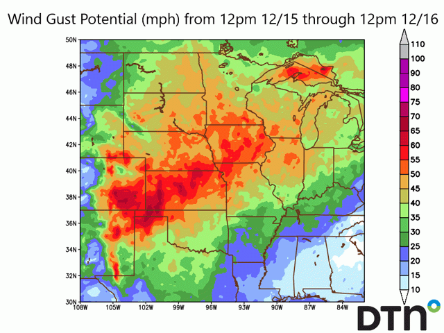
With a stronger set of dynamics around the system, winds are more likely to be mixed down to the surface from the system and it will be much stronger than we saw last week. Some areas of the Southern Plains saw wind gusts go more than 50 miles per hour last week. This week, forecasters are anticipating wind gusts approaching or exceeding 70 mph across a wide area of the Central Plains from South Dakota down to the Texas Panhandle and then eastward into Iowa.
Winds will come on strong mid-morning and last through the afternoon and evening before quickly diminishing in the evening and overnight hours from southwest to northeast as the low-pressure center passes through. Power outages across a wide area almost seem like a certainty from this storm.
The powerful storm system that moved through the country late last week produced a band of heavy snow across the northern Corn Belt and severe thunderstorms in the Midwest and Midsouth. That storm garnered a load of media coverage with regard to the severe storms and long-tracked tornado that went through four states.
Additional information on that storm's development and impact can be found here: https://www.dtnpf.com/… and here: https://www.dtnpf.com/….
P[L1] D[0x0] M[300x250] OOP[F] ADUNIT[] T[]
The upper-level pattern that set up the system last week is a little different than the one this week, thus some of the features are different. The troughs are not in the same position or with the same depth. But some of the features are still similar.
For one, there is very warm and moist air out ahead of the system. In fact, temperature anomalies on Dec. 15 will be greater above normal than they were last week. High temperatures may reach 70 degrees Fahrenheit for places such as Omaha in Nebraska, Des Moines in Iowa, and Peoria, Illinois. At least for Des Moines, temperatures that high would break the all-time December high. Low-level moisture is also quite significant as we see dew points approaching 60 degrees Fahrenheit into the Mid-Missouri Valley.
Another similar feature will be a deepening low-pressure system. Last week, the low-pressure center that moved through Kansas and then northeast into the western Great Lakes deepened, which drew moisture farther north for efficient snow generation and increased shear for organizing thunderstorms. This low-pressure system is doing something similar, deepening as well and pulling moisture northward. It will actually deepen more significantly than last week's storm and that is the first of the differences.
This influences the winds being stronger than last week.
The storm track is going to be different too, going from Nebraska through Minnesota instead of Kansas through Wisconsin, and this will affect the severe weather potential. The mid-level moisture will not be as great, and the shear may be too high to organize thunderstorms into significant supercells like we saw rip through the Midwest and Midsouth. Instead, we are more likely to see a low-topped line of thunderstorms with an enhanced wind threat. Some tornadoes will still be possible, however.
Another difference will be the timing. We are more likely to see the severe threat in the late afternoon and evening hours instead of overnight -- more of a traditional severe weather time frame than last week. But there are threats roughly over the state of Iowa and the immediate adjacent areas.
Last week the Storm Prediction Center had a large and expansive "Enhanced" risk of severe weather the day before the event across the southern Midwest and Midsouth. Today, their risk is just a small slight area centered around west-central Iowa. But please be aware that although the risks are lower for severe weather and tornadoes, it is still a concern. If anything, hopefully last week's event is a reminder that severe weather can still happen in December, but it is rare.
The only thing missing from this week's storm will be the snow. The system will be pulling away so quickly that snow that develops on the backside of the storm will not accumulate as much as the more than 12 inches that occurred in a long band last week. Instead, just a few inches are expected.
With extremely strong winds and severe weather anticipated for Dec. 15, another significant storm system is set to hit Middle America in December.
John Baranick can be reached at john.baranick@dtn.com
(c) Copyright 2021 DTN, LLC. All rights reserved.
Comments
To comment, please Log In or Join our Community .