
Ag Weather Forum
Heavy Snow, Severe Weather Highlight Weekend Storm
A "wintertime spring storm" -- that has a sort of oxymoron sound to it, but it is the feeling on the mind of this meteorologist on the conditions that led to a strong system that produced heavy snow across the northern side of its track and widespread severe weather to its south.
Conditions set up near-perfect to produce the widespread impacts that this storm produced, but it was unusual for December. We often see these types of scenarios in March and April, sometimes even September and October, but December? Weather sometimes has a humbling or sobering quality to it. The course of events that unfolded Dec. 10-11 should reaffirm in the minds of all of us that strong weather can happen at any time of day, at any time of year, and at any place.
PERFECT CONDITIONS SET UP STORM IMPACTS
A really strong storm system is set up by a couple of things. The first is a contrast in temperature. Temperatures were in the 60s Fahrenheit in the eastern Midwest and in the 70s and 80s Fahrenheit in the Midsouth and Southern Plains Friday afternoon ahead of a strong cold front. Temperatures behind the system were in the 20s and 30s Fahrenheit in the Upper Midwest and Northern Plains. The strong difference in temperature sets up strong dynamics to build a deepening low-pressure system.
As a storm deepens, winds rush more quickly around it. Wind gusts in the southwestern Plains were recorded at 50 to 60 miles per hour, indicative of a strong low-pressure system that developed in eastern Colorado, then moved through Kansas and northeast through the western Great Lakes. A trough of cold air aloft in the West met the warm ridge in the East, and the stage was set.
Not only was the air warm east of the Mississippi River, it was also fairly moist. Dew point temperatures were not far below air temperatures, creating a pool of strong instability that feeds thunderstorms. The deepening of the low-pressure system in the Plains only increased this moisture flow from the Gulf of Mexico northward. To the north, dew points even in the colder section were quite significant just above the surface, which allowed for efficient snowmaking. The effect of the temperature contrast and warm, moist air made for the "perfect storm" of conditions to create widespread impacts to the middle of the country Dec. 10-11.
P[L1] D[0x0] M[300x250] OOP[F] ADUNIT[] T[]
HUGE SNOWFALL BAND AFFECTS NORTHERN CORN BELT
Snow began to fall as the trough was still in the Western U.S. on the night of Dec. 9. The deepening low pressure drew air toward the mountains. As the air runs into the mountains, it is forced to rise. The relatively moist air fed a band of moderate to heavy snow along an old frontal boundary that was draped from southeastern Wyoming and near the Nebraska-South Dakota border. It is hard to describe in text, but increasing dynamics drew air farther into the low-pressure center and created a zone of enhanced lift, referred to by meteorologists as "frontogenesis."
Frontogenesis is a fancy term to describe the effect of a front. On one side, you have rising air, and on the other, you have descending air. When a zone of frontogenesis is strong and does not move very much, we see increased precipitation but with a sharp cutoff where the air was descending. Such a band developed and tracked with the low-pressure center as it moved across South Dakota, Minnesota, Wisconsin and the Upper Peninsula of Michigan.
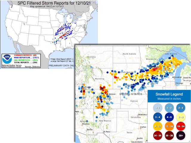
The result was a relatively thin band of snow of greater than 6 inches. In most cases, the band was less than 60 miles wide, though it widened a bit in eastern Minnesota and Wisconsin. But this led to a sharp cutoff as well. Snowfall at the Minneapolis airport, which is on the south side of the metropolitan area totaled 11.8 inches from the storm. To the north, reports came in at 4-5 inches just 17 miles away. And across the river just 5 miles away in Burnsville and Eagan, Minnesota, reported amounts were 15 to 18 inches. The same sort of snowfall gradient was evident from South Dakota all the way through Michigan.
SEVERE WEATHER HITS MIDWEST, MIDSOUTH
What garnered the most attention out of the system was the severe weather that occurred with the storm Friday night into Saturday morning, Dec. 10-11.
All the ingredients you want to see for severe weather were there. There was ample instability, or fuel for thunderstorm development, with surface temperatures in the 60s and 70s Fahrenheit with dew points not far from that. There was a deepening trough providing shear to organize storms. And there was a triggering mechanism -- a front that moved across the region to initiate thunderstorm development. All of these ingredients made for an easy call to issue severe weather outlooks, watches, and warnings.
The Storm Prediction Center issued a Day 2 Convective Outlook on Dec. 9 and noted the potential for nocturnal tornadoes and continued that wording the following day when it increased its threat from an "enhanced" threat to a "moderate" threat of severe weather. The center issued a tornado watch box that encompassed the main source region at 3 p.m. Central Standard Time, at least three hours prior to the first tornado report. The center extended it northward and eastward during the following three hours to essentially cover all of the territory that would be affected by tornadoes that evening, providing hours of notice to those within the threat areas.
But the advanced warning does not stop the weather from occurring -- 60 tornadoes were reported in nine states, though some of these were of the same tornado over long distances. And 393 wind reports filled in the gaps where tornadoes didn't from northeast Texas to Illinois and New England to Georgia.
There was one tornado that has focused national media attention, as it devastated a wide path from northeast Arkansas to central Kentucky. That tornado formed from a long-tracked supercell that appears to have put down a continuous damage path of about 250 miles. It will take days or perhaps weeks for all the National Weather Service offices that were affected to survey the damage. But if they conclude that it was one single, continuous tornado, it would be the longest-tracked tornado ever recorded, beating out the infamous Tri-State Tornado from March 18, 1925, which had a track of 219 miles and killed 695 people. It has already garnered the moniker the "Quad-State Tornado" by several media outlets and individuals, as it went through Arkansas, Missouri, Tennessee and Kentucky.
You can read more coverage about this tornado here: https://www.dtnpf.com/….
But that one tornado was not the only one of the evening. Another long-track supercell produced tornadoes from just north of St. Louis through central Illinois. The Amazon distribution center in Edwardsville, Illinois, suffered a major collapse after a tornado went right through it, killing at least six people. Several other tornado reports produced property damage, injuries, and deaths in Illinois, Indiana, Ohio, Missouri, Tennessee and Mississippi. The damage is widespread and will take months or years to recover.
The system was odd because the severe weather occurred farther north than we typically see for December. It is a rare event anyway, but when severe weather occurs in December, it is more likely to occur near the Gulf Coast and the source for heat and moisture. That was not so with this system, which is rewriting some record books. Like I mentioned above, severe weather does not occur only in a certain place at a certain time. When the conditions are right, tornadoes, hail and damaging winds can occur, and it is always best to be cognizant of the weather, even when you are not within the highest-risk period for your area.
John Baranick can be reached at john.baranick@dtn.com
(c) Copyright 2021 DTN, LLC. All rights reserved.