

Ag Weather Forum
Warm End to Crop Year 2021
The U.S. crop year 2021 ended on a high note -- in this case, temperatures that were well-above normal. USDA highlighted some details of central U.S. October warmth in its weekly crop weather bulletin of Nov. 9.
The bulletin reported that on Oct. 5-6, consecutive daily-record highs were established in North Dakota locations such as Minot (91 and 90 degrees Fahrenheit) and Dickinson (93 and 87 F). Other record-setting highs for Oct. 5 included 90 F in Glasgow and Miles City in Montana. Bismarck, North Dakota, had a high of 91 F on Oct. 5, its 51st reading of the year with a high of 90 F or higher, second only to 53 such days in 1936.
In Texas on Oct. 9, daily-record highs soared to 100 F in Childress, 98 F in Borger, 97 F in Midland, and 96 F in Lubbock and Amarillo. Childress' reading marked the latest triple-digit reading in that location since Oct. 13, 1954, when the high was 100 F, said USDA.
P[L1] D[0x0] M[300x250] OOP[F] ADUNIT[] T[]
Farther north, a daily-record high of 96 F occurred on Oct. 9 in Wichita, Kansas. On Oct. 10, La Crosse, Wisconsin, had a high temperature of 81 F and a low of 63 F. This marked La Crosse's 109th day this year with a maximum reading of 80 F or greater, and the 101st day with a minimum of 60 F or higher. Previous records in La Crosse had been 108 days (in 1998) and 100 days (in 2018), respectively, according to the bulletin.
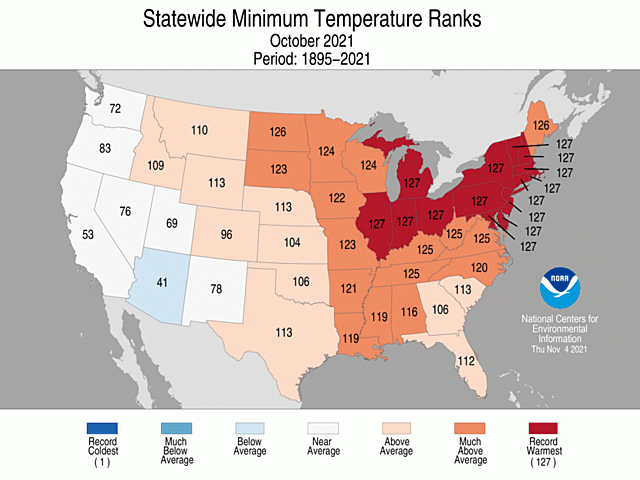
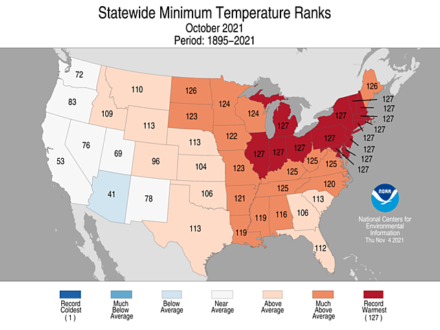
But those hot days had plenty of corresponding warm nights. Every state from the Rockies east to the Atlantic coast had average minimum temperatures that were above normal to much-above normal in October. And most of the Midwest, Mid-Atlantic, and New England had the highest statewide minimum temperatures in 127 years of record keeping -- from 1895 to 2021.
This warmth meant that row crops had an extended stretch at the end of the season to fill out and ripen. It's much different than a year ago, when freezes in September ended the growing season. And behind this notable warmth was a stable weather pattern, according to DTN long-range forecaster Jeff Johnson. "The pattern was persistent in October, with a blocking high over eastern Canada," Johnson said. "That meant that there was not a log of colder air coming south." Johnson also pointed to the development of upper-atmosphere low pressure off the North America west coast, which meant a consistent inflow of Pacific Ocean-origin air across the contiguous U.S. This Pacific-origin flow also helped storm systems to form in the north-central U.S. with some heavy rainfall events, which in turn brought significant easing of dryness and drought.
So, to borrow from poet James Whitcomb Riley, October did not produce much "frost on the punkin" -- but it helped put some heavy "fodder in the shock." If you'd like, you may enjoy that poem here: http://www.yourdailypoem.com/…
Bryce Anderson can be reached at Bryce.anderson@dtn.com
Follow him on Twitter @BAndersonDTN
(c) Copyright 2021 DTN, LLC. All rights reserved.
Comments
To comment, please Log In or Join our Community .