

Ag Weather Forum
Upper High to Raise Growing Degree Day Count
How long has it been since the term "ring of fire" was used in connection with a weather forecast? A year? Two years? I am pretty sure that the PBS documentary series "Country Music" -- which featured the "Ring of Fire" song by Johnny Cash -- had its run since the last time this reference to upper air features in the central U.S. was mentioned.
In weather terms, "ring of fire" refers to the development of a large area of high pressure in the upper atmosphere that locates somewhere in the central United States. When these features happen, they can bring hot and dry weather to a large area of crop country. When an intense upper level high is in place, any storms that develop tend to be at the edge of the high, and sometimes form what looks on radar like a ring around the center of the dry and hot high. Thus, you have the "ring of fire."
These hot features are not new; they've happened before, and to devastating effect. We certainly saw a ring of fire in 2012 over the entire central U.S.; also in 2011, 2000, 1995, 1992 and in 1988. Those years had heat and dryness that caused a notable reduction in crop size.
P[L1] D[0x0] M[300x250] OOP[F] ADUNIT[] T[]
Forecast models point to such an upper level high parking over the south-central U.S. during the first 10 days of June. This is a big change from a stagnant ridge west-trough east pattern that's been around for much of the spring season so far. But whether the upper level high formation is automatically going to mean harsh heat and dryness for crops is still to be determined.
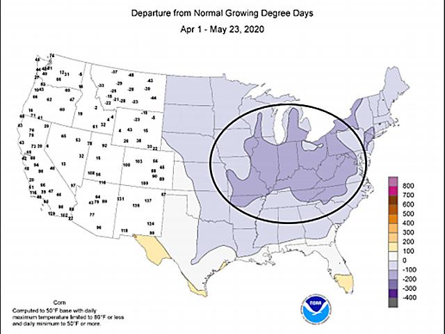
One benefit of the upper atmosphere high is likely to be in the form of more favorable temperatures for crop progress. A key measure of weather favorability for crop development, Growing Degree Day totals, is running below average in the central U.S. so far this season. In fact, much of the Midwest has Growing Degree Day totals lagging the average by from 100 to 300 Growing Degree Days. So, as long as the temperature is not extremely high, those Growing Degree Day totals will offer plants the chance to be active, set roots down, go through the photosynthetic process, and truly get growing.
Another reason for confidence about limited stress with the oncoming West Coast-origin high is how it will interact with abundant soil moisture. Much of the central U.S. east of the 100th longitude meridian has soil moisture supplies in at least the 90th percentile. That soil moisture is available to be drawn up and into the atmosphere profile. A parcel of air that rises eventually cools to the point of condensation. When there are enough of these bubbles of warm moist air, they form clouds. When the clouds are heavy enough, it rains. And, after the rain, the air cools -- which takes away some of the stress from hotter conditions.
The evolution of the upper air high in the next 10 days will be closely tracked. In addition, the prospect of this feature redeveloping during the summer will also, of course, be a big point of interest as the crop season continues.
Bryce Anderson can be reached at bryce.anderson@dtn.com
Follow him on Twitter @BAndersonDTN
© (c) Copyright 2020 DTN, LLC. All rights reserved.

Comments
To comment, please Log In or Join our Community .