

Ag Weather Forum
Heat With Showers, A Good Combination
Planting during the last week of May progressed well despite another week of moderate to heavy rainfall. Corn is near completion (93%). Progress was slower in the eastern Midwest but still ahead of average. The only state that sticks out is North Dakota at 75% complete compared to 90% on average. Soybeans are now 75% planted with the slower progress in the Delta. Cotton planting is right on average at 66% complete. Spring wheat planting has almost completed with only North Dakota behind schedule. Though at 85% complete, the state has made good progress over the last week (15 percentage point increase).
With planting finishing up for most crops, weather concerns have turned an eye more on the weather for emerging crops. A slow-moving system dropped copious amounts of moisture over the eastern Plains eastward last week. Most areas saw at least 0.50 inch of rainfall and areas in eastern Kansas and Oklahoma to western Arkansas up through Wisconsin reported more than 3 inches. Short-lived Tropical Storm Bertha also brought heavy rain to southern Florida and into the Carolinas. All of this was good for those crops poking out of the ground, except for areas of flooding which did occur.
P[L1] D[0x0] M[300x250] OOP[F] ADUNIT[] T[]
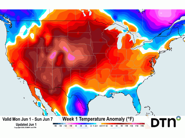
The pattern has flipped this week and warmer weather has spilled across the Rocky Mountains into the Plains and Midwest as of June 2. The heat ridge responsible for the warming looks to hold firm through this coming weekend. Normally a ridge of this magnitude is concerning for crops as the heat can become very stressful. However, with the recent rains and abnormally high soil moisture, the heat instead will allow crops to play catchup, as the growing degree days have been well below normal, as mentioned in DTN Senior Ag Meteorologist Bryce Anderson's blog on May 29. Heat and good soil moisture are a good combination for early developing crops.
And thankfully for most areas, it won't be a dry heat. Disturbances moving across the U.S.-Canada border this week will bring periods of showers at least to northern areas through June 6, further benefiting developing crops. Unfortunately for winter wheat in the southwestern Plains, the heat will come with limited to no showers and continue to stress the crop. Crop ratings in Kansas have stabilized but a trend downward is expected with this weather forecast.
This pattern will not last long. A strong trough and its associated cooler temperatures will build into the Pacific Northwest over the weekend. This trough will also induce a large storm for the northern tier of the country next week with strong winds and periods of moderate to heavy rainfall. While the heat will go away, it is not going to be very cold east of the Rockies; instead, there will be a cooling trend toward normal temperatures.
Then: the tropics. Tropical Storm Cristobal was identified on the afternoon of June 2 in the southern Gulf of Mexico near the Bay of Campeche. It is the earliest occurrence on record of the third named tropical system in the Atlantic Basin. This storm is expected to meander in the south for the next several days but start moving north over the weekend. The track looks to bring landfall around the north Texas or western Louisiana coast Sunday or Monday. That obviously could change but as it continues to work its way northward into the Plains, Delta, and Midwest, tropical moisture and heavy rainfall will be a concern for flooding along its track.
John Baranick can be reached at john.baranick@dtn.com
© (c) Copyright 2020 DTN, LLC. All rights reserved.

Comments
To comment, please Log In or Join our Community .