

Ag Weather Forum
El Nino-Related Moisture System Targets Southwest Plains

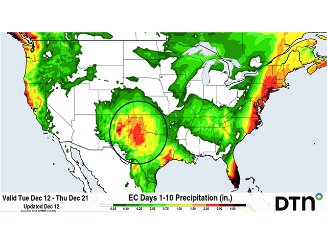
For the first time in several years, weather forecast models are suggesting a generous helping of wintertime rain and snow in the Southwest Plains and Texas Panhandle due to a system known as a cutoff low.
A cutoff low is defined by the NOAA National Weather Service as "A closed upper-level low which has become completely displaced (cut off) from basic westerly current and moves independently of that current. Cutoff lows may remain nearly stationary for days, or on occasion may move westward opposite to the prevailing flow aloft (i.e., retrogression)." In the current case, the weather system formed in the Pacific Northwest, then tracked into the Grand Canyon region of Arizona, and moved slowly eastward while the main jet stream continued moving from west to east across the northern U.S.
While the cutoff low slowly tracks eastward, its surface wind pattern brings moisture from the Gulf of Mexico into the Southwest Plains and Texas Panhandle. That atmospheric moisture then translates into rain and snow as the storm center gets closer to areas like the southern end of the Rocky Mountains in New Mexico, the Southwest Plains, and the Texas Panhandle.
P[L1] D[0x0] M[300x250] OOP[F] ADUNIT[] T[]
Cutoff lows have a strong relationship to El Nino events, according to USDA Ag Meteorologist Brad Rippey. "This type of slow-moving storm, featuring an amplified subtropical jet stream, is consistent with El Nino," Rippey told DTN in an email. "While you can't blame a single storm on El Nino, a winter pattern with wetness in the South and mild, dry weather in the North is characteristic of a warm-phase episode."
Precipitation forecasts call for as much as 2 to 3 inches in eastern New Mexico, west Texas and the Texas Panhandle, with one inch-plus amounts in the Oklahoma Panhandle and southwest Kansas. The precipitation suggested recalls a similar event that produced heavy snow in west Texas back in January of 2015. "In that 2015 event, Amarillo, Texas, picked up 12.0 inches of snow on Jan. 21-22. Lubbock had 3.4 inches (of snow)," Rippey said.
Moisture generated from this week's cutoff low will be useful. Much of the Southwest Plains and Texas-Oklahoma Panhandles have had easing of drought conditions, but the region is still running short on root-zone soil moisture following harsh dryness over the past several years. "Currently, very little of the (Southwest Plains) region is listed in drought on the U.S. Drought Monitor, but anecdotal reports in the region seem worse than what is listed on the map," noted DTN Ag Meteorologist John Baranick.
This week's rain and snow potential does offer benefits for winter wheat and will help improve the moisture supply for next year's dryland cotton crop. And the indicated precipitation is highly significant.
"The forecast amounts of over an inch are more than the full month's-worth of rain," Baranick said. "Amarillo, Texas, averages 0.71 inches in December. Clayton, New Mexico, averages 0.42 inches in December. Lamar, Colorado just 0.46 inches. Dodge City, Kansas 0.96 inches."
The mid-December precipitation may be followed by additional occurrences. Forecast models are hinting at another round of rain and possible snow during the week after Christmas, giving a moisture boost to usher in 2024. That would be a sharp difference from the parched conditions in the Southwest Plains over the previous several New Year observances.
Bryce Anderson can be reached at Bryce.Anderson@dtn.com
(c) Copyright 2023 DTN, LLC. All rights reserved.
Comments
To comment, please Log In or Join our Community .