

Ag Weather Forum
Chances for a White Christmas?
Bing Crosby made it popular and the lyrics of White Christmas come barreling over the airwaves this time every year. According to the National Weather Service, a white Christmas can be defined as having a 1-inch snow depth on Christmas morning. For those in the western mountains or north of I-80, that is generally a good chance -- a roughly 50% chance or greater. The closer you get to Canada or the higher your elevation is, the greater the chance. You can find a map of the historical probability here: https://www.weather.gov/….
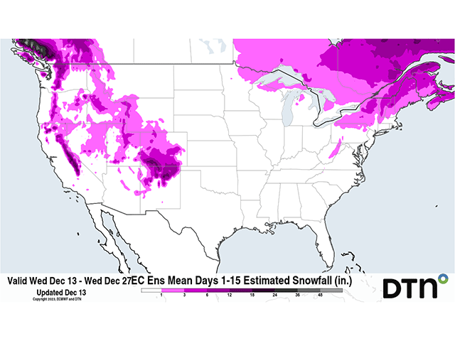
Currently, there is some snow on the ground up by the Canadian border. Snowfall late last week put down some snow cover in and around North Dakota; parts of the northern Midwest have snow from that event as well, though it is pretty light by all available data. The mountains in the Northeast also have snow cover, as well as many of the higher elevations in the West. You can find information on the latest snow cover here: https://www.nohrsc.noaa.gov/…. This map shows that snow cover in many of these areas outside of the higher elevations have little depth. In other words, a turn of warm weather could easily melt away the snow and leave the ground bare prior to Christmas.
In fact, a big burst of heat is forecast to build across North America for the rest of this week and continue in the lead-up to Christmas as well. An upper-level ridge will expand across Canada and be a dominant feature over most of North America for at least the next two weeks. That promotes above-normal temperatures across most of southern Canada and the U.S. It is not a guarantee that the snow currently on the ground will melt away prior to Christmas, but with forecast high temperatures in the upper 30s and 40s Fahrenheit, a solid 10 to 15 degrees above normal in some locations, it will be hard for the snow to stick around.
But even with above-normal temperatures, it can still be cold enough to snow over parts of the country -- mainly the northern tier, but also in the High Plains. So how do chances for additional snow look through Christmas Day?
Not great. With the ridge so far north, the jet stream, which carries the primary storm track, is well off into Canada. Storm systems over the northern tier of the country will be limited to passing fronts, many of which will be dry. The southern tier of the country is more active, though, a classic upper-air pattern during El Nino. A cutoff low-pressure center is currently building a storm system in the Southern Plains. DTN Ag Meteorologist Emeritus Bryce Anderson wrote about that storm on Tuesday here: https://www.dtnpf.com/….
P[L1] D[0x0] M[300x250] OOP[F] ADUNIT[] T[]
Areas of moderate and even heavy snow will be falling in portions of the southern High Plains, particularly in southeast Colorado and northeast New Mexico, where amounts may get close to, or even eclipse, a foot. Even with higher temperatures to follow, it may make melting that snow difficult to do before Christmas morning. However, that system is going to be too warm to create snow for others as it moves across the Gulf Coast this weekend and then up the East Coast for early next week. Higher elevations in the Northeast again look to be at risk of further snowfall, but that is probably it.
Following that storm, it looks like a rather dry week across the U.S. But another cutoff low-pressure system will meander off the West Coast and bring periods of precipitation to the western states most of the week. California looks to have the greatest chances at precipitation, but alas, it will be too warm for snow outside of the higher elevations again.
Models do have some uncertainty with this trough though. The European model consistently keeps the storm system off the coast through the week, bringing it into the Southwest late next week or weekend, in the few days prior to Christmas. At the same time, the American GFS model is more intent on bringing that storm system through the West and into the Plains by the end of next week, Dec. 22-23, and then through the middle of the country over the weekend, Dec. 23-25. Temperatures with that system would be borderline for snow. But borderline is as good as any for getting some accumulation in the Plains and Upper Midwest.
In talks with DTN Long-Range Weather Risk Analyst Nathan Hamblin on Dec. 13, Hamblin noted the sort of presentation the GFS is hinting at is not out of the question, but there's a low probability.
"The jet stream comes roaring across the Pacific toward the coast next week, with a strong split down to the south (across Mexico). The northern extension is very weak and there is a lull over the middle of the U.S. A more southern storm track, from California through the Gulf Coast makes more sense. Usually those lull areas produce below-normal precipitation," he said.
Given the southern storm track is more likely, it would also delay precipitation until after Christmas east of the Rockies.
So, to recap, a white Christmas is typical over the higher elevations and those across the north. Some snow already exists in some portions of the north, but the higher temperatures in the lead-up through Christmas are likely to melt a lot, if not all, of that snow outside of the higher elevations. Snow falling in the southwestern Plains through Dec. 15 may be significant enough to last until Christmas, but that is an unknown. And the forecast beyond Dec. 15 suggests a low probability of additional snow outside of the western mountains. Chances are not zero for those in the Plains or Upper Midwest, but low.
We may have to find another song to sing. Sorry to Bing and the rest of those hoping for a winter wonderland this Christmas.
To find more weather conditions and your local forecast from DTN, head over to https://www.dtnpf.com/…
John Baranick can be reached at john.baranick@dtn.com
(c) Copyright 2023 DTN, LLC. All rights reserved.

Comments
To comment, please Log In or Join our Community .