

Ag Weather Forum
Break in La Nina, Stronger Polar Vortex Leading to Warmer January
After another visit from the polar vortex last week that spread through most of the country, temperatures have made a drastic turnaround to end the month. Due to the extreme cold, temperatures for the month of December are significantly below normal for most of the country outside of the Southern Plains and Northeast.
But January is going to be a drastic change from the last two months in one significant way -- the polar vortex will be much stronger. Typically, La Nina conditions in the tropical Pacific Ocean lead to a weakened polar vortex -- the jet stream that circulates around the North Pole. When the polar vortex is weak, it tends to break into pieces, sending cold, arctic air southward. We have seen a few of those events so far in November and December, with the one last week the most intense of them all. Conversely, when the polar vortex is strong, the jet stream circles the North Pole rather easily and uninterrupted. That locks the cold, arctic air closer to the North Pole.
January is going to feature a much stronger polar vortex in the first two weeks for the most part. It may not be completely over the North Pole. Instead, it will be dislodged a bit into Siberia and the North Pacific. That will help to build a source of arctic air in Russia. Eventually, this pattern will break down and a return to a fragmented polar vortex will bring new threats of arctic air to North America. That should hold off until either late January or early February. Models will need to work out some timing there.
P[L1] D[0x0] M[300x250] OOP[F] ADUNIT[] T[]
But, in the meantime, enjoy some warmer weather for a while. We have earned it after going through the last couple of months, especially for those in the Northern Plains and Canadian Prairies. (If you missed seeing it, here's the blog I wrote about some of the extreme temperature drops last week from a polar vortex impact on the U.S.: https://www.dtnpf.com/…)
This pattern is usually more active as well and will be during the next two weeks. A conglomeration of troughs and the polar vortex over the North Pacific will send several pieces of energy through North America for at least the front half of the month. That will mean at least some chance for normal or above-normal precipitation for the month.
With the pattern shaping up, the West, South, and East Coast have the best chances to see the storm track through these areas, and increasing moisture, which should help to reduce drought a bit further. The signal is not as great in the southwestern Plains though, where drought is the deepest in the country.
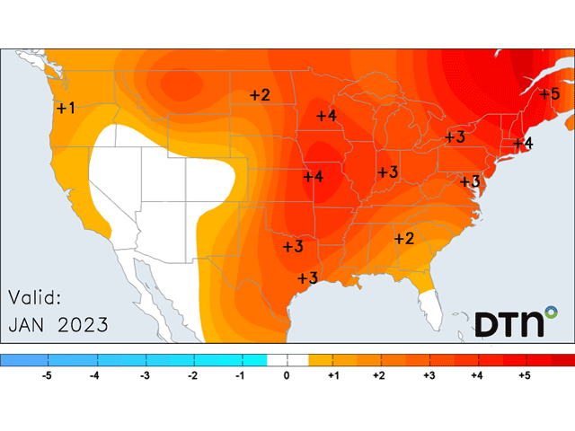
These storms will not have access to that arctic cold. They will be pacific in nature and milder throughout the country. Temperatures may still go below normal for a day or two behind each system, and snow will still be possible, especially for northern areas. But, overall, temperatures should average out above normal, and in some cases well-above normal, for most of the country outside of the Desert Southwest, which should average close to normal.
Do not be lulled to sleep, though. La Nina, though weakening, is still in control of our weather for another couple of months. Its tendency for clippers and arctic air will return. Look for the last week of January or the beginning of February for that pattern to return.
To find updated radar and analysis from DTN, head over to https://www.dtnpf.com/…
John Baranick can be reached at john.baranick@dtn.com
(c) Copyright 2022 DTN, LLC. All rights reserved.

Comments
To comment, please Log In or Join our Community .