

South America Calling
Argentina's Corn and Soybean Hold on While Showers Are Variable
Argentina was having such a good run of weather up until mid-January, when the pattern seemed to change for the worse, giving the country a two-week stretch of almost no rain and attendant heat. Since then, February has been more forgiving with the temperatures, but rainfall has been erratic.
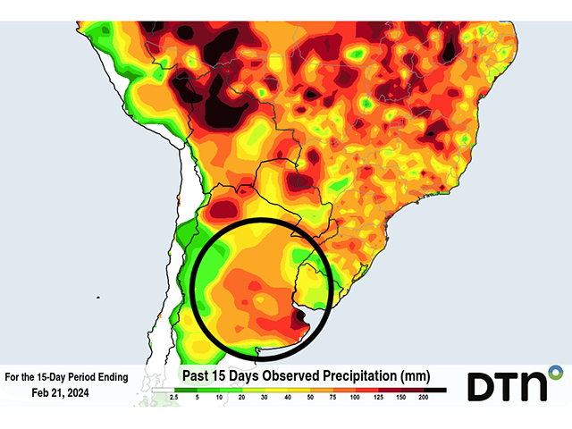
Rainfall during the last 15 days points to widespread amounts over 50 millimeters (about 2 inches) across the country, with heavier rainfall over the state of Buenos Aires which has seen more than 100 mm (about 4 inches) and some spots over 150 mm (about 6 inches). But that has come in fits and starts and much of that heavy rain came in a two-day period at the end of the dry spell and very little has fallen since. Rainfall of this magnitude does not all penetrate into the soil and some of it runs off, so the effective amount of water that entered the soil is much less. That amount is dependent on soil type and rainfall rate, so it is hard to find an effective rainfall total. But suffice to say, not all of that rain has soaked into the surrounding soils and some soil moisture deficits still exist, even in those areas with the heaviest rainfall.
P[L1] D[0x0] M[300x250] OOP[F] ADUNIT[] T[]
With little rainfall since the heavy burst a couple of weeks ago, soils are drying out again. Crop conditions stabilized over the last two weeks, but the slight reduction in soil moisture noted in today's report from the Buenos Aires Grain Exchange (BAGE), points toward worsening conditions if rain does not return. And that comes in a critical time for both corn and soybeans in the country. In the same BAGE report, soybeans are 54% setting pods and 21% filling; corn is 82% tasseling and 67% silking.
For the benefit of the crops, rainfall is headed back into Argentina this week. On Feb. 22, a front is bringing a wave of decent showers through the country. This is setting up a slightly more active period of rainfall in which several waves of showers will move across the landscape through at least Mar. 3. However, northern areas are forecast to see the most consistent showers, which may add up to more than 100 mm. But southern areas, the most productive farmland, are expected to see more sporadic showers out of the waves, likely totaling less than 30 mm (1.2 inches) in most areas. And they are forecast to be more hit-or-miss types, which could leave some areas without much accumulation during the next 10 days.
Crops are hanging on during the up-and-down conditions, but this sort of variable weather is troubling for some, especially for crops across the south.
To find more international weather conditions and your local forecast from DTN, visit https://www.dtnpf.com/….
John Baranick can be reached at john.baranick@dtn.com
(c) Copyright 2024 DTN, LLC. All rights reserved.

Comments
To comment, please Log In or Join our Community .