
Ag Weather Forum
Snow, Severe Thunderstorms and Well-Below-Normal Temperatures This Week
As I look out my window here in east-central Minnesota, it's certainly difficult to imagine getting out in the fields anytime soon, let alone getting the planter out of the shed to prep for corn and soybean planting. The snow depth here is currently around 12 inches. Last year at this time, the snow depth was less than half this value, at 4 inches on March 10, 2022.
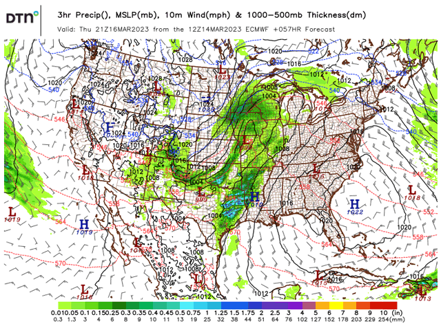
Unfortunately, this year's snowpack will likely get added to in the coming days. An area of low pressure that entered California early Tuesday will work east through the Great Basin on Wednesday and eventually reach the Plains and Mississippi Valley Thursday.
Areas of heavy rain have been falling across much of the northern half of California Tuesday morning along with wind gusts near 40-55 mph with this low-pressure system. On Tuesday night and Wednesday morning, this system will work east, crossing over into the Great Basin. Snow will develop across much of the northern Great Basin and higher elevations of the central Great Basin. Up to 12 inches of fresh snow is forecast across these areas, with isolated higher amounts up to 20 inches possible in the highest elevations of the Rockies.
Through Wednesday afternoon and Wednesday night, precipitation will start to enter the northwest Plains. Snow will be possible across the Dakotas while a mix of rain and snow will develop in Nebraska. Wind gusts will also pick up as precipitation develops, with gusts up to 30-40 mph possible in the Northern Plains Wednesday night. Through Thursday morning, precipitation will gradually increase in coverage across much of the Plains and Upper Midwest. A wintry mix of precipitation and snow will extend from central Nebraska into southwest Minnesota while scattered rain showers will extend from central Texas into western Illinois.
P[L1] D[0x0] M[300x250] OOP[F] ADUNIT[] T[]
Into Thursday afternoon and Thursday night, the area of low pressure will continue working east across the middle of the country. Isolated thunderstorms, some of which may become strong to severe, will develop in central Texas Thursday afternoon and may eventually grow upscale into a broader thunderstorm complex Thursday evening as this activity pushes into eastern Texas and far western Arkansas and Louisiana.
Meanwhile, snow will continue across the Upper Midwest and portions of the Central Plains. Gusty winds from the northwest will also accompany precipitation Thursday afternoon and early Thursday evening across the Upper Midwest and Central Plains as a cold front works through. Wind gusts up to 35-45 mph are possible across these regions. Through Friday morning, most of the precipitation will work east out of the Mississippi Valley while scattered snow showers will linger across the Upper Midwest and Northern Plains.
Widespread precipitation across the Central U.S. will be likely after this low-pressure system passes through. Some areas of eastern Texas, Louisiana, and Arkansas could see 1 to 2 inches of rainfall, with isolated higher amounts up to 3 inches. Some tributaries of the Mississippi River in the South-Central U.S. are already at a minor flooding stage, and with the additional rainfall in the forecast, more tributaries will be at risk of approaching flood levels. In addition to the flooding risk, this round of forecast rainfall will halt any chances of getting out and doing some early fieldwork across these areas.
Across the North-Central U.S., forecast snowfall with this system is not as clear-cut. A band of 2 to 8 inches of snow could extend from northeast Nebraska into northeast Minnesota and northern Wisconsin. Within this band, isolated higher amounts near 10 inches could be possible. Confidence in these forecast snow amounts is low and could change as new model runs come in on Wednesday and early Thursday. Even while these snowfall amounts could change going into Thursday, snowfall certainly appears likely across areas of the North-Central U.S. Furthermore, with more snowfall in the forecast comes the decreased likelihood of getting out in the fields early.
On top of the heavy rains in the South-Central U.S. and snowfall in the North-Central U.S., cold air will filter in behind this system. Below- to well-below-average temperatures are expected across much of the central part of the country by Friday and these temperatures will continue into the upcoming weekend and into early next week. Some of the coldest weather anomalies are expected across the Northern Plains, where temperatures could approach 15-25 degrees Fahrenheit below normal. Low temperatures Friday morning through Sunday morning could plunge to the single digits below zero across the Dakotas. For livestock operations in these areas, higher inputs will likely be required to keep animals warm.
Between the heavy rains and thunderstorms expected across the Southern Plains and Southern Mississippi Valley to the potential for heavy snow and sub-zero temperatures in the Northern Plains and Upper Midwest, this low-pressure system will offer setbacks. Early fieldwork in the south may come to a halt while northern areas will see additional snowfall on top of the lingering snowpack, reducing chances of getting out into the fields early.
To find more regional weather conditions and your local forecast from DTN, head over to https://www.dtnpf.com/….
Teresa Deutchman can be reached at teresa.deutchman@dtn.com
(c) Copyright 2023 DTN, LLC. All rights reserved.

Comments
To comment, please Log In or Join our Community .