
South America Calling
Spotty Showers Insufficient in Argentina, Southern Brazil

Drought near the poles typically means an absence of rain. Closer to the equator, drought means significantly below-normal rainfall. It can still rain, sometimes moderately so, while drought continues to build. It's a distinction worth noting as we continue to see drought conditions in Argentina and southern Brazil as we shift focus from the early planted and first crop to late-planted and safrinha (second-crop) corn and soybeans. The fate of the earlier-planted varieties has all but been sealed by the dryness that has enveloped this region of the world since December. Going forward, the development of corn and soybeans in Argentina and central Brazil will take center-stage for the remainder of the 2021-2022 crop season.
I have written extensively on the drought and its impact on the crop situation in Argentina and southern Brazil for some time. And it feels like I am beating a dead horse to say that yes, it is still going to be drier than normal in those areas for the next month. But that does not mean there will not be any precipitation at all.
P[L1] D[0x0] M[300x250] OOP[F] ADUNIT[] T[]
Drought conditions held through 4 to 6 inches of rainfall in central Argentina in mid-late January, and worsened in northern Argentina that still received over 2 inches of rain. So even if there is rain in the forecast, it does not mean that crop conditions will improve.
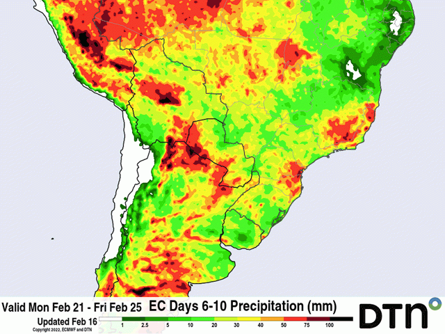
That brings us to the forecast. There will be some spotty showers through Feb. 23 through Argentina and southern Brazil. But the spottiness will mean only very localized areas will see any precipitation greater than 25 millimeters (1 inch). However, models are pointing to a bit more active period for the end of the month and possibly into early March as well. More widespread coverage of 25 to 50 mm (about 1 to 2 inches) is looking likely. Early developing corn and soybeans in Argentina and newly planted safrinha corn in southern Brazil will certainly soak up all they can get. But it will be insufficient to turn around the prospects for the crops, especially as models bring back the dryness for the month of March.
The same is not true in central Brazil. Daily scattered showers have been almost a constant feature since the wet season started up in late September and early October. With no letup in the pace or intensity, it has been a little more difficult to get soybeans out of the field and plant corn, and transportation of soybeans out of the country has reportedly been slower as well.
While the pace of corn planting has slowed some in Mato Grosso, which produces over 40% of Brazil's safrinha corn crop, they are still ahead of the normal schedule and well within the preferred planting window for corn. That window is going to start closing in a few days, however. Crops planted after the third week in February run the risk of going into pollination and grain-fill during the dry season and would need to rely on subsoil moisture to carry the remainder of the crop through. That task is doable, but risky when temperatures consistently run up to 40 Celsius (104 Fahrenheit). For now, the precipitation continues to support corn growth once it is in the ground.
To find more international weather conditions and your local forecast from DTN, head over to https://www.dtnpf.com/…
John Baranick can be reached at john.baranick@dtn.com
(c) Copyright 2022 DTN, LLC. All rights reserved.
Comments
To comment, please Log In or Join our Community .