South America Calling
La Nina Pattern Showing Up for South America
La Nina, characterized mostly by below-normal temperatures in the central Pacific, has strengthened during the last couple of weeks. The Climate Prediction Center, a division of NOAA in the U.S., declared La Nina to be in effect on Oct. 14, but the Bureau of Meteorology in Australia has yet to call it. They did move to La Nina Alert status on Oct. 12, indicating conditions are very close to having a true La Nina state. Ocean conditions have cooled both at the surface and well below the surface in the tropical Pacific Ocean.
The Bureau of Meteorology also noted that most of the precursors are in place for the event to take shape by November and continue through the Southern Hemisphere summer before gradually moving toward a neutral state in Southern Hemisphere fall.
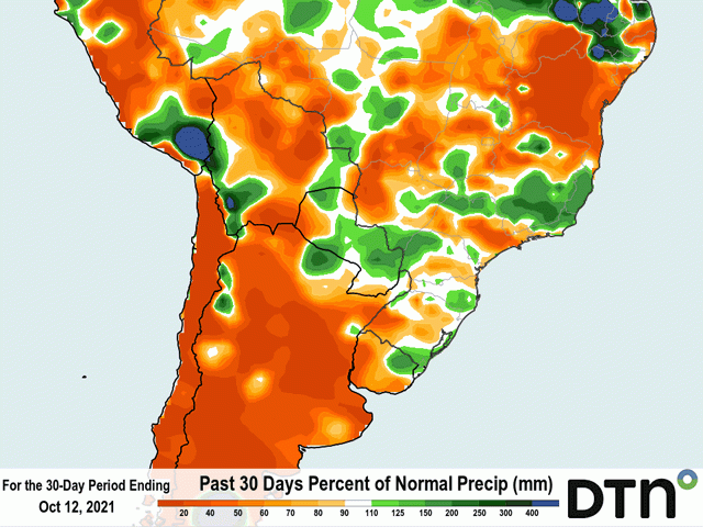
Springtime in South America during a La Nina event is usually characterized by a delay to central Brazil's wet season, and below-normal rainfall across Argentina and southern Brazil. The delay did not occur, but showers had been lighter and spottier up until this past weekend. That is most likely because the season started before La Nina really had much of an influence. However, Argentina has seen below-normal rainfall during the last 30 days especially. In the attached image, rainfall amounts have been only a fraction of normal with most areas seeing less than 50% of normal precipitation.
P[L1] D[0x0] M[300x250] OOP[F] ADUNIT[] T[]
DTN Ag Meteorologist Emeritus Bryce Anderson talked about the strengthening La Nina in his Oct. 8 blog: https://www.dtnpf.com/…. He mentioned that Argentinian farmers may put off planting corn and soybeans to avoid drier conditions during reproduction in December and January.
I would tend to agree with that risk assessment, but Argentinian farmers are apparently going through with planting anyway. They space out their planting from September through December to reduce risk of drier periods affecting too much of the crop. According to the government of Argentina, corn was 26% planted as of Oct. 7, 2% higher than last year. Producers may feel that they are doing their due diligence by still planting some of their crop now, just in case the forecast does not pan out. Soybean planting has not been reported in the country yet.
The current situation is not good for most of the country's primary corn and soybean areas. Soil moisture in Argentina is currently modeled to be below normal for most of country. Scattered showers this week have not made much of a difference to too many areas. A frontal boundary is moving through the country Oct. 14-15 with scattered showers and then a period of near-complete dryness is anticipated through much of next week. Temperatures will be below normal behind the front. That should help somewhat with limiting evapotranspiration, but the country still needs more moisture.
That front should also clear the skies over southern Brazil next week as well. This is the pattern that La Nina typically produces. Fronts from systems move through Argentina and southern Brazil with some isolated or scattered showers before going through several days of dryness. Sometimes, the rains come with enough regularity to be timely for crops, even if amounts are disappointing. Producers may have to count on that again this year.
This front should make for about a week of dryness before the next system comes through late next week or weekend to do much of the same. It is and will be a tough time for early growth for corn and soybeans for the next couple of months as La Nina strengthens and continues to influence world weather patterns. Later-planted crops may end up having a better season again this year as long as rains can come back in with more frequency and intensity during the summertime. If the drier pattern continues, crop yields could fall no matter when it was planted.
John Baranick can be reached at john.baranick@dtn.com
(c) Copyright 2021 DTN, LLC. All rights reserved.


Comments
To comment, please Log In or Join our Community .