South America Calling
La Nina Impact to Continue
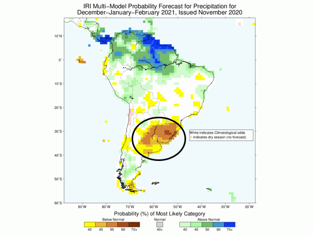
A closely watched climate analysis and forecast agency, the International Climate and Research Institute (IRI), headquartered in New York City, released its updated forecasts for the next three- and six-month periods Monday. The forecast keeps the chances high for continued dryness and drought potential in the U.S. Southern Plains and in the South America crop regions of southern Brazil and Argentina.
The IRI forecast description features these details:
"The SST (sea surface temperature) forecast is for moderate to strong La Nina conditions to continue through winter, likely weakening during the spring but persisting as a weak La Nina. Warm SSTs in the North and South Pacific, southeast Indian Ocean, and the North and South Atlantic are forecast to persist through the spring while the tropical Atlantic Ocean remains near normal.
"Precipitation forecasts for the coming season are consistent with typical La Nina teleconnections. In December to February, strongly enhanced probabilities of below-normal precipitation are forecast for Mexico and the Southern U.S., southeast South America, with moderately enhanced probabilities of below-normal precipitation in Southwest Asia. Enhanced probabilities of below-normal precipitation persist in the Southwestern U.S. through March-to-May, but relax towards climatology elsewhere by Jan-March."
P[L1] D[0x0] M[300x250] OOP[F] ADUNIT[] T[]
The southeast South America region described in the IRI summary is an area the includes the state of Rio Grande do Sul southern Brazil, the entire country of Uruguay, and northern through central Argentina. These are primary row crop producing areas. Rio Grande do Sul is the third-largest soybean production state in Brazil; and in Argentina, the coverage of dry conditions in the IRI forecast includes the states of Santa Fe, Cordoba and Buenos Aires -- the top three corn and soybean producing states in Argentina.
Farther north, the central Brazil state of Mato Grosso is not in a widespread high chance category for dry conditions; however, indications are that precipitation will be near to below normal. Central Brazil is already in a drier pattern; thus, the message is that of a higher chance for reduced crop size in South America than previous estimates.
In the U.S., dry conditions remain prominent in the IRI forecast for the Central and Southern Plains, and from the southern California coast east to the Carolina coast. Below-average precipitation in the Southern Plains forecast leads to more concern about lower winter wheat output from this region in 2021. Above-average moisture has a high probability in the Northwest, with near- to above-average precipitation indicated for the Midwest during the winter season.
**
Editor's Note: Be among the first to hear Bryce Anderson's 2021 weather outlook, and its implications on crop yields and markets, by attending this year's DTN Ag Summit, Dec. 7-9. Our premier farmer and rancher event is virtual this year, and features thought-provoking presentations on global trade, grain and livestock market outlooks, a look at how farmers are using data to increase profits and build resilience into their operations, the latest on tax issues and many other topics. Speakers include U.S. Ambassador Kip Tom, farmers Reid and Heather Thompson and farm blogger Meredith Bernard, Microsoft Chief Scientist Ranveer Chandra, personal development speakers David Horsager and Jon Gordon, and many more.
You can take part in it all from the comfort of your office or tractor cab. Register at www.dtn.com/agsummit
Bryce Anderson can be reached at bryce.anderson@dtn.com
Follow him on Twitter @BAndersonDTN
(c) Copyright 2020 DTN, LLC. All rights reserved.


Comments
To comment, please Log In or Join our Community .