Canada Markets
Manitoba's May 1 to June 20 Precipitation
Long-term precipitation graphics from Agriculture and Agri-Food Canada continue to show dry conditions for Manitoba. The Percent of Average Precipitation for the past 365 days, as of June 21, shows most of the province having received 60% to 85% of normal precipitation or below, with one area of the southeast corner of the province having received less than 40% of normal precipitation during the past year. This is the largest area with this rating on the Prairies, with only a small area in eastern Saskatchewan also below 40%.
The provincial government's Crop Report as of June 22 states that precipitation is needed to support crop development, while stress already faced in crops is leading some crops to an earlier-than-normal maturity.
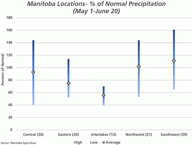
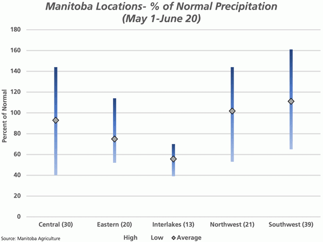
The attached graphic shows the wide range of precipitation realized between May 1 to June 20. The location monitored by the province in the Central Region having received the least precipitation as a percent of normal is 40%, while the location in the Interlakes Region having the lowest precipitation as a percent of normal is reported at 39%. These locations have received the lowest amounts of cumulative precipitation as a percent of normal, defined by the province as the 30-year 1971-to-2000 precipitation.
The locations reporting the highest amounts of precipitation for this period as a percent of normal are seen in the Central and Northwest Regions that have both received 144% of normal precipitation since May 1 and one location in the Southwest Region having received 161%.
P[L1] D[0x0] M[300x250] OOP[F] ADUNIT[] T[]
The Interlakes Region is showing the lowest line on the chart, with the 13 locations monitored ranging from 39% to 70% of normal precipitation since May 1.
While not shown, 14 of 30 locations in the Central Region (1 of 29) show precipitation received in this period above 100% of average, along with 1 of 20 for the Eastern Region (5 of 19), 0 of 13 for the Interlakes Region (0 of 14), 11 of 21 for the Northwest Region (1 of 22) and 26 of 39 locations in the Southwest Region (1 of 40), with year-ago results in brackets. Three of the five regions are showing an improvement year-over-year, the Eastern Region is showing a less-favourable situation from last year and the Interlakes Region is showing data unchanged year-over-year. While the amount of precipitation received is a factor, the timing may be of greater importance.
The black markers represent the average across the locations reported for each region. The average for the number of locations reported for the Northwest Region and the Southwest Region is above 100% of normal precipitation at 101.8% and 111.1%, respectively, while the Central Region is just below 100% of normal at 92.9%. The lowest average is calculated for the Interlakes Region at 55.7%.
**
DTN 360 Poll
In advance of Statistics Canada seeded acreage report, due for release on June 29, what do you think will be the most obvious changes made to the acreage mix? You can weigh in with your ideas on this poll, which is found on the lower-right side of your DTN Homepage.
Cliff Jamieson can be reached at cliff.jamieson@dtn.com
Follow him on Twitter @Cliff Jamieson
(c) Copyright 2021 DTN, LLC. All rights reserved.


Comments
To comment, please Log In or Join our Community .