Ag Weather Forum
Moisture Deficits Highlight Importance of Forecast Rain in Western Corn Belt
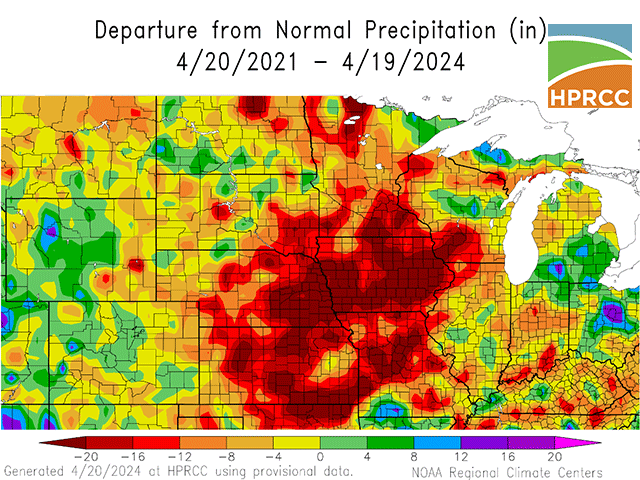
Upcoming central U.S. rainfall over the next 10 days is getting attention for potentially interrupting corn and soybean planting. But this period of wetter conditions also offers a significant benefit for soil moisture improvement.
That is especially true in the Western Corn Belt, where precipitation deficits are large. Precipitation deficits in much of the Western Corn Belt -- including almost all of Iowa -- are 20 or more inches below normal over the past three years.
A review of Iowa's soil moisture assessment brings more perspective to the need for additional precipitation. The state's crop progress report for the week of April 15-21 showed soil moisture at 63% adequate to surplus. That total was higher than the previous week's 48% but lagged a year ago when the adequate to surplus total came in at 78%. Iowa's subsoil moisture is also below a year ago with 45% rated adequate to surplus compared to 65% adequate to surplus at the same time in 2023.
P[L1] D[0x0] M[300x250] OOP[F] ADUNIT[] T[]
USDA Midwest Climate Hub director Dennis Todey told DTN in an email he sees a short-term/long-term divide when it comes to soil moisture in the Western Corn Belt.
"The shorter-term deficits (back to six months) are not too bad and the profile -- at least (the) upper part -- is mostly in good shape east and most everywhere nearer the surface," Todey said. "(The) deeper profile I expect is still drier in parts of Iowa, Kansas, Nebraska and Missouri. And definitely, groundwater is showing the effects of that one- to three-plus-year deficit."
Looking further ahead, forecasts for the Pacific Ocean temperature and barometric pressure pattern to change from El Nino (warm ocean) to La Nina (cool ocean) indicate a higher prospect for drier conditions in the central U.S. by midsummer. La Nina brings a stronger chance for dry and hot high pressure to settle over the central U.S., just at the time when crop water needs -- and evapotranspiration -- are at their maximum.
"My real concern is midsummer when we get into really dry periods and the deeper profile cannot supply water needed to meet demand. We could see some more widespread stress given what we see in the outlooks and what we know about El Nino-La Nina transitions," Todey said.
Long-range forecasts for summer 2024 mainly call for above-normal temperatures and below-normal precipitation in the central U.S., especially the Western Corn Belt. That places a high level of importance on upcoming rainfall prospects to help stabilize the soil moisture reserves.
For more information on the precipitation outlook, read this from DTN Ag Meteorologist John Baranick: https://www.dtnpf.com/….
Bryce Anderson can be reached at Bryce.Anderson@dtn.com
(c) Copyright 2024 DTN, LLC. All rights reserved.


Comments
To comment, please Log In or Join our Community .