
Ag Weather Forum
Needed Moisture Coming to Upper Midwest
It has been an active pattern here in March and pretty warm as well. We've seen several big storm systems produce widespread rainfall through the Central Plains, Ohio Valley and the Deep South. But an area that has been missed frequently is the Northern Plains and Upper Midwest.
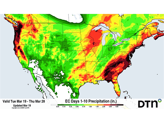
Drought has been slowly building back into these areas and soil moisture is low throughout much of these two regions. From Montana to Wisconsin, it has been hard to get a bunch of moisture into anything other than small locations. Soil moisture maps show these areas are begging for some rain, especially from the South Dakota-Nebraska border northeast through Wisconsin. Iowa has been participating in some better rainfall recently, but subsoil moisture is still lacking because of long-standing deficits we can trace back to 2020.
However, the pattern is setting up to bring these areas several chances for meaningful precipitation. The recent pattern involved the storm track being split around these areas with active conditions across central Canada and the southern U.S. But that is changing this week. An upper-level trough in central Canada will be stuck for a few days and guide some disturbances eastward from the Pacific later this week.
First, we'll see a clipper-like storm move from Montana through Michigan on Thursday and Friday. Like most clippers, there will only be streaks of showers that move through. However, the system's track from Wyoming through Ohio will mean the northern side of the storm, which is typical of clippers, will have a good band of snow working across the region with it.
P[L1] D[0x0] M[300x250] OOP[F] ADUNIT[] T[]
Again, like clippers, the exact snowfall potential is being worked out with this system. But a band of 6 or more inches is possible along the North Dakota-South Dakota border through lower Michigan. Some rain will be possible near the low's track, which may get some decent showers along the South Dakota-Nebraska border through Iowa and northern Illinois as well. That would certainly be helpful by itself, but there will be a bigger storm coming this weekend into next week.
In fact, it looks like it'll be a double-barreled system that moves through. Instead of just one low-pressure center, it will likely be two. Some models have a third later next week. But keeping with the idea of two, the first low-pressure center moves into the Central Plains on Saturday evening and the Upper Midwest on Sunday. Warm air ahead of that system will lead to a mix of precipitation types that will cover much of the Dakotas, Nebraska, Minnesota, Iowa and Wisconsin, according to the latest forecast.
The second low-pressure center will develop right behind it in the Southern Plains Sunday night as it moves northeast through the Great Lakes on Monday and Tuesday. Another round of increasing rain and snow is likely over the eastern Plains through the Midwest. Iowa, Minnesota and Wisconsin all stand to benefit from this storm as well as drier areas in the Plains and Ohio Valley.
When all three storms are added together, it's more than an inch of liquid equivalent across the eastern Plains and Mississippi Valley, hitting the hardest drought areas in and around Iowa, Minnesota and Wisconsin with more than two inches. Models are consistent -- and insistent -- on that scenario, but we know how model forecasts can change, especially when systems are close to a week away.
That's doubly true with the snowfall forecast. While it is unknown how much snow will occur with these systems, Minnesota seems to be in the epicenter of all three low-pressure centers at this time, resulting in 12-18 inches across a good portion of the state. Snowfall of that caliber would likely double the seasonal snowfall total in Minneapolis, which has had a paltry 14.3 inches so far in this incredibly warm winter season. The current total is more than 30 inches below normal through this date. And other areas in the neighborhood have also had a snow drought this year.
Warm soils and the lack of snow cover will lead to snow melting relatively quickly, but also soaking into the soils where it is needed. That may be more difficult to do with cold air following the weekend's double system, but those in the area will take all the precipitation they can get, regardless of which type.
To find more weather conditions and your local forecast from DTN, head over to https://www.dtnpf.com/…
John Baranick can be reached at john.baranick@dtn.com.
(c) Copyright 2024 DTN, LLC. All rights reserved.

Comments
To comment, please Log In or Join our Community .