
Ag Weather Forum
Needed Rain Coming for Southern Plains Wheat
The development of significant wildfires Feb. 27-28 in the Texas Panhandle can be blamed on recent warm and dry conditions that have not abated. Add in strong winds with an overall active spring pattern and the Smokehouse Creek fire has become the largest in Texas history.
The wildfires are a symptom of recent conditions from late winter and early spring that have sapped soil moisture in the Central and Southern Plains, even after a winter that had built in above-normal precipitation and subsoil moisture for much of the region.
That is about to change. A storm system March 6 in the West will be moving into the region on March 7 and is forecast to produce widespread showers and thunderstorms in the region through March 8 before the system heads eastward. Some of these storms may be severe from central Texas up into southern Kansas on March 7 and across eastern Texas and Oklahoma into the Gulf Coast areas on March 8.
P[L1] D[0x0] M[300x250] OOP[F] ADUNIT[] T[]
Hail is the largest threat, but strong winds and a couple of tornadoes would also be possible. On the backside of the system, it will be cold enough to produce pockets of snow, which may be moderate or even heavy in some locations. Northeastern Colorado and southwest Nebraska look to be most at risk of accumulating snow. Here, accumulation may exceed 6 inches, though exact amounts are difficult to diagnose with borderline temperatures and uncertain precipitation rates.
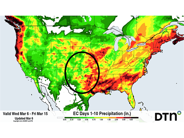
The true benefit of the storm will be incoming rain. It will come in scattered showers but many in the region can expect to see around 1/2 inch to 1 inch of liquid equivalent. That does not seem enough for an area that has been particularly dry over the last couple of weeks, but that is just the first system.
Another system is forecast to move into the region in much the same way as the first on March 13-14 with another day or two of scattered showers and thunderstorms. This one is less likely to produce snowfall, but it is too early to make that designation yet. Severe storms may also be possible again, too. But another round of an inch or so of rainfall, which may be more widespread than the first storm, would be the benefit. When put together, the two storms should produce widespread areas over 1-1/2 inches of liquid with many areas over 2 inches due to enhancement from thunderstorms. Of course, some areas are likely to be left behind due to the scattered nature of the showers.
West Texas would be the primary area less likely to see total amounts over an inch but the culmination of two storm systems should help provide more soil moisture for a wheat crop advancing through its growth stages early due to the excessive warmth over the winter.
Crops are in good condition for the most part, and certainly when compared to the last three spring seasons, but additional moisture will be needed soon to keep those conditions in a favorable rating. Good news for the region is that the rain is on track to arrive in most areas of the Southern Plains wheat areas.
To find more weather conditions and your local forecast from DTN, head over to https://www.dtnpf.com/…
John Baranick can be reached at john.baranick@dtn.com
(c) Copyright 2024 DTN, LLC. All rights reserved.

Comments
To comment, please Log In or Join our Community .