

Ag Weather Forum
The Winter That Barely Was: Temperatures Near Warmest on Record This Season, Thanks to Super El Nino

In many regards, this past winter season wasn't much of a winter season at all. With the turn to meteorological spring on March 1, a look back at winter (December-February) shows us it was near-record warm for the season across the northern tier of the country.
Even a visit from the polar vortex in mid-January couldn't bring down the anomalous warmth throughout the season. Most areas saw little snowfall when compared to normal and the snow that did fall never lasted too long. That comes despite many areas seeing above-normal precipitation. And some early severe weather events occurred in February as well.
This is almost a textbook representation of the winter season during a strong El Nino. This year's sea-surface temperatures in the tropical Pacific Ocean reached up to a three-month average of 2.0 degrees Celsius above the historical average. A reading of just 0.5 degrees C above normal is required for El Nino conditions. The reading of 2.0 was a historical marker only reached five other times in the reliable records that go back to 1950. Meteorologists and climatologists colloquially refer to this as a super El Nino and this super El Nino certainly made its presence known throughout the season.
P[L1] D[0x0] M[300x250] OOP[F] ADUNIT[] T[]
El Nino favors above-normal temperatures across the northern tier of the country by splitting the jet stream into two pieces before reaching North America. The northern section of the jet builds up over western Canada and falls over eastern Canada, locking up the cold, Arctic air closer to the North Pole, or displacing it to Europe or Asia. The southern extension of that jet is the more energetic one, favoring an active storm track across the southern tier of the U.S. Increased precipitation is favored, but because of that precipitation, temperatures are fairly moderate as compared to the north.
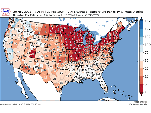
This played out almost to perfection all season long. Temperatures across the northern tier of the country were, in fact, very warm almost all season long. Days below normal were limited to a couple of days here or there that were not very intense and followed up by a warm burst of air on most occasions. Although El Nino was in control for almost the entire winter season, it did have a break. And that came with a significant burst of cold air from the polar vortex that set up in western Canada in mid-January and spilled into the Plains and Midwest with a seven- to 10-day stretch of very cold air. Areas farther west and south had more limited bursts of the Arctic air but it did take over the entire country for a limited time. Despite that, the winter still averaged out near-record warm across the northern tier of the country. When looking at preliminary data from Iowa Environmental Mesonet, the majority of the Midwest recorded a Top 5 warmest winter on record. That includes eastern South Dakota, all of North Dakota, Minnesota, Iowa, Wisconsin (in which all climate districts in the state recorded the warmest winter on record), Michigan and Ohio, as well as most of Missouri, Illinois and Indiana. That also extended into most of the Northeast U.S. If not for that visit from the polar vortex, the rest of the Northern and Central Plains would likely have shared in the near-record warmth as well.
The southern jet stream certainly was active most of the season as well with above-normal precipitation from California through the Carolinas, though southwest Texas did see amounts below normal. That was enough to significantly reduce or eliminate drought across the southern tier of the country. What was once D4 drought across Louisiana and parts of Mississippi has gone to D1 or lower with some areas now drought-free. Long-term deficits in the eastern Plains and around Iowa have been reduced as well, though they still stand in some areas.
With the warmer temperatures farther north and a more southern storm track, that meant a lack of significant snowfall throughout most of the country east of the Rockies. Minneapolis, Minnesota, was on track for the lowest recorded snowfall in its history until a quick burst moved through in mid-February that brought about 6 inches. Even so, the total snowfall for the season, which stands at just 14.3 inches since July, is well below the seasonal average of 39.9 inches and last year's total of 71.4 inches as of March 1. The lack of cold air has severely limited the total amount of lake-effect snow in the Great Lakes. That polar vortex burst did set up some significant snowfall from Kansas and Nebraska through the Midwest, including the snowiest week in the history of the Quad Cities on the Mississippi River between Iowa and Illinois, at about 2 feet. But even then, the seasonal snowfall for the Quad Cities is right near normal and all that snow has since melted. Most areas in the Northern Plains and Midwest have seen below-normal snowfall. The only areas to see above-normal amounts were in parts of Kansas, Nebraska and along the Iowa-Missouri border.
And to go along with the warmer temperatures and storm track, some severe weather visited farther north as well. Typically, severe weather can occur during winter but usually sticks down toward the Gulf of Mexico where warm waters still pump in decent moisture that clashes from colder air coming down from Canada and collides near the coast. We did see a few of these events this winter but this season, we saw severe weather a bit farther north into the Northern Plains and Midwest. A small severe weather event occurred in early February in northern Illinois and southern Wisconsin. And then a low-key but early outbreak occurred at the end of February with 21 tornadoes now recorded from northern Illinois into southern Michigan and across central Ohio to go along with more wind and hail reports.
The only part of the textbook El Nino pattern that did not occur was precipitation in the Ohio Valley. Usually, El Nino favors drier conditions here and an increase in drought was a concern going into the season. However, these areas saw near-normal precipitation during the season and drought was actually reduced in many areas.
To find more weather conditions and your local forecast from DTN, head over to https://www.dtnpf.com/…
John Baranick can be reached at john.baranick@dtn.com.
(c) Copyright 2024 DTN, LLC. All rights reserved.
Comments
To comment, please Log In or Join our Community .