
Ag Weather Forum
Argentina Going Through Dry Couple of Weeks
The weather could not be much better for a lot of Argentina during the last couple of months. Consistent and persistent rainfall, though too heavy at times, has put the corn and soybean crops in very good shape. According to the Buenos Aires Grain Exchange weekly agricultural overview report released Jan. 18, just 3% of corn and 2% of soybeans are rated in poor condition.
That is an immense turnaround from the 47% and 56% ratings a year ago, respectively. Though soil moisture and crop conditions are currently in very good shape, we may see those ratings falling during the next couple of weeks because of a much drier forecast.
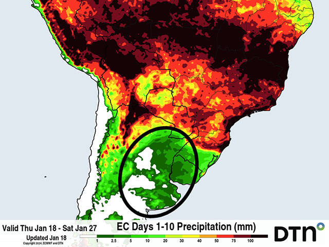
A system drifted north out of Argentina and into southern Brazil and Paraguay on Jan. 17. The front brought another round of good rainfall to the country and soil moisture is high. However, outside of some isolated showers in Buenos Aires Jan. 18 and against the Andes in the far west Jan. 21, weather models are very dry across the country through at least Jan. 28 and possibly into early February.
P[L1] D[0x0] M[300x250] OOP[F] ADUNIT[] T[]
Developing to reproductive corn and soybeans can take a period of dryness with little interruption to their development, but two weeks would be too long. Areas that have only adequate soil moisture are likely to run short by the end of the month, and those with abundant soil moisture may get close to being marginal in the same time frame. The drier period is going to hurt early planted corn that is in its pollination and grain-fill periods and soybeans that are just starting to get into their blooming and pod-setting stages. In other words, crop conditions are most certainly to fall by the end of January and start of February and could hurt production if it is severe enough.
If there is any good news for Argentina, it is that temperatures do not look to be overly high, despite the drier conditions, at least for the next seven days. In fact, temperatures are likely to run a couple degrees below normal for most of the country through Jan. 24. High temperatures in the 30-35 degrees Celsius (86-95 degrees Fahrenheit) range will be common. Temperatures in that range will ensure that crops will transpire readily, but overnight lows in the 13-20 C (55-68 F) range will keep down the stress to the afternoon only.
Above-normal temperatures may start building up from the south to close out January though. If the rain does not come back by the end of the month, those temperatures could be stressful as soil moisture declines.
Production estimates for the country continue to be high, and nearly double the production of last year's drought-reduced crop. But further adjustments upward in production are not likely until this drier period passes and any potential damage is assessed.
Longer-range models are mixed on the precipitation prospects for the first half of February. While the European model is more aggressive at bringing in good rainfall first to southern Argentina, and then northern Argentina by the middle of the month, the American GFS is less optimistic. Rainfall patterns return to normal for the south, but continue to run short across the north and into southern Brazil as well. Indeed, even after some good rainfall during the last week, southern Brazil will also be drier and could use more rainfall for immature crops and the coming safrinha (second-season) corn crop.
To find more international weather conditions and your local forecast from DTN, visit https://www.dtnpf.com/….
John Baranick can be reached at john.baranick@dtn.com
(c) Copyright 2024 DTN, LLC. All rights reserved.

Comments
To comment, please Log In or Join our Community .