Ag Weather Forum
Storm System Prior to Thanksgiving Will Send Temperatures Plummeting
It has been on the radar for a while now, but a major storm system is forecast to cross the country this weekend through early next week, bringing widespread precipitation to a lot of the country and causing temperatures to fall prior to Thanksgiving weekend.
I mentioned the possibility in last week's blog here: https://www.dtnpf.com/…. And though the upper-level forecast did change from last week and is no longer typical of the El Nino, which may have to wait until early December, the storm system mentioned is still on track.
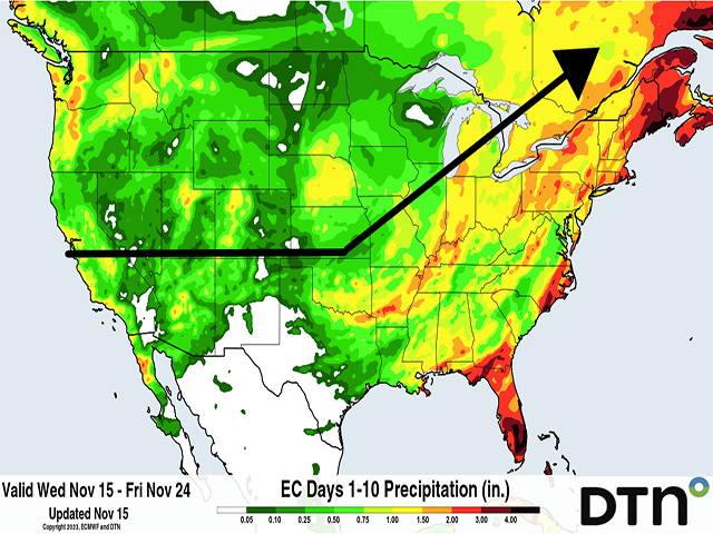
A trough off the West Coast will shift into the Southwest this weekend and as it does so, will bring a storm system through California and the Four-Corners area, getting into the Central and Southern Plains Saturday night or Sunday, Nov. 18-19. The storm system should develop a deeper low-pressure center and then arc northeast through the Midwest into Ontario and Quebec on Nov. 20-21 as it wraps up in Hudson Bay Nov. 22.
P[L1] D[0x0] M[300x250] OOP[F] ADUNIT[] T[]
This storm would likely bring widespread precipitation to a large section of the country, and certainly for those in drought and in need of refilling soil moisture prior to the winter freeze.
Amounts around or over an inch are forecast from the European ECMWF model and its ensembles in parts of California and the Rockies, sections of the Central and Southern Plains, and much of the country east of the Mississippi River outside of the Upper Midwest. The incoming rain will help to ease drought conditions that continue to be a problem in parts of the Plains and Midwest while those near the Gulf Coast that have seen drought increasing in recent weeks could see a pause to that expansion.
Furthermore, water levels on the Mississippi River, which have fallen again this week in response to recent dry conditions in the Missouri, Upper Mississippi, and Ohio river basins, could see good rises with this precipitation as well.
The storm system will also cause temperatures to fall. Ahead of this storm, it has been very warm this week. Many days with highs in the 60s and 70s Fahrenheit have been anywhere from 10 to 25 degrees F above normal depending on the location. Though a cold front will race through the country Nov. 16-17 and bring temperatures down closer to normal for many areas for a day or so, they should perk back up ahead of this storm system. Following the storm, temperatures will drop back to or even a little below normal early-to-mid next week.
However, this system will allow another push of cold air to work down from Canada and spread through more of the country for the rest of the week and weekend, which may or may not come with a storm system of its own. Temperatures are forecast to fall anywhere from 5 to 15 degrees F below normal around Thanksgiving and over the holiday weekend, closing out November on a cold note for most locations east of the Rockies. In contrast, those in the West will see less of a cool-down from the system and those in the interior may see increasing temperatures prior to Thanksgiving, though they are likely to fall again that weekend.
There are some inconsistencies in the models, and details are still being worked out. But a major storm system is forecast to move through this weekend into early next week, followed by a run of colder air for most areas, especially for those east of the Rockies.
To find more weather conditions and your local forecast from DTN, head over to https://www.dtnpf.com/…
John Baranick can be reached at john.baranick@dtn.com
(c) Copyright 2023 DTN, LLC. All rights reserved.


Comments
To comment, please Log In or Join our Community .