
Ag Weather Forum
Double-Edged Sword of Rainfall for Middle of US
With harvest underway, the weather forecast takes a bit of a turn. Instead of needing rainfall for growing crops, farmers would prefer drier conditions for fieldwork. It has been very dry for a lot of areas during the last month, but a system is forecast to bring some areas of heavy rain this week that could throw a wrench into their machinery and slow them down. Of course, with the drier conditions has come building drought, and the rainfall will help to ease some of those concerns.
According to USDA NASS' Crop Progress report valid for Sept. 17, over half of this year's corn and soybean crops are mature and await harvest (54% mature for corn, 54% dropping leaves for soybeans). Harvest continues to pick up at 9% complete for corn and 5% complete for soybeans. A couple of mostly dry days early this week should get those combines rolling a little quicker, but not all areas will be that lucky.
A couple small disturbances found themselves in the middle of the country and, as of early Tuesday morning, were producing areas of showers from Iowa into northern Illinois and from Kansas down into far northern Texas. Showers are mostly light in these areas, but there is a string of heavier rain with the northern disturbance across central Iowa. These two disturbances will continue to be active the next couple of days, but the northern one will fizzle out on Wednesday and the southern one will move into the Ozarks where there are fewer acres of cropland.
But there is a big change coming. A trough is digging southward into the western U.S. here on Tuesday while a ridge develops over Canada. The trough will take a stroll eastward this week and produce a strong storm system beginning in the Northern Plains on Wednesday, and for the rest of the Plains on Thursday. With the ridge strengthening over Canada, the trough will be cut off from the jet stream, which will mean it should move very slowly eastward through this weekend and next week.
P[L1] D[0x0] M[300x250] OOP[F] ADUNIT[] T[]
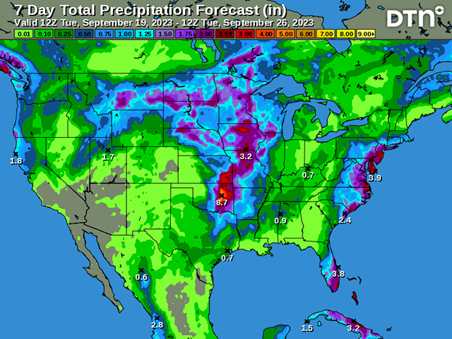
Several rounds of showers and thunderstorms can be expected from the system, which will be able to tap into moisture coming up from the Gulf of Mexico to feed some heavy rain showers coming over multiple days. Current forecasts suggest that this storm system weakens on Sunday, with lighter and more sporadic showers east of the Mississippi River for early next week before the system makes it to the East Coast late next week. The heaviest rain will be along and near the Mississippi River west to the Rockies, though not all areas in that corridor will see heavy rain. Still, this is the biggest shot of rain for a large section of the country's growing areas in over a month.
Rainfall amounts are forecast to be in the range of 1-to-3 inches with areas of heavier rain and some areas with lower based on where thunderstorms track. Severe weather will also be a potential threat. No doubt, multiple days-worth of moderate to heavy rain will halt harvest progress for a lot of the country.
But it's not all bad news, of course. Soil moisture has been in decline throughout most of the country between the Rockies and Appalachians during the last several weeks. Drought has expanded and deepened in many areas of the Corn Belt and Deep South. While southern areas may not receive enough to reverse the momentum of the building drought, the Corn Belt likely will, especially over the western end.
Many areas that have forages or immature crops could use the moisture to put on additional weight, though that percentage continues to drop by the day. Also, those looking to plant winter grains should find some additional soil moisture helpful for establishment.
With how deep the drought has become in these areas, and with soil moisture so low, heavy rain will largely soak right in and keep the harvest and fieldwork delays relatively short. The rain will also have a positive impact on the water levels in the Mississippi River, which have become critical again with restrictions forced on barges moving up and down the River. You can read more about that here: https://www.dtnpf.com/….
A caveat to fieldwork is in the southwestern Plains, a major production area of winter wheat, which forecasts are noticeably drier than areas to the north and east. That would be helpful for planting, which has only just started in the states of Kansas, Colorado, Oklahoma and Texas. Recent rainfall here has kept soil moisture a bit higher, favoring germination and establishment. The need for additional rainfall is not very high right now, and so getting another week of drier weather may not be all that bad right now.
To find more weather conditions and your local forecast from DTN, head over to https://www.dtnpf.com/…
John Baranick can be reached at john.baranick@dtn.com
(c) Copyright 2023 DTN, LLC. All rights reserved.

Comments
To comment, please Log In or Join our Community .