

Ag Weather Forum
Derecho Rips Through Southern Corn Belt
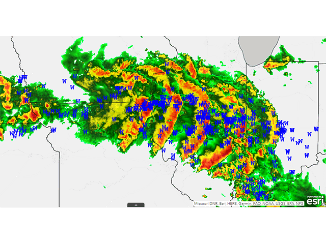
As feared, a derecho ripped through the southern Corn Belt on Thursday. A derecho is a long-duration windstorm that puts down continuous storm damage with several of those being hurricane-force (over 74 mph) for at least a distance of 240 miles. They typically occur with a bow echo, which is a way of describing how the system looks on radar with a pronounced arc to the leading edge of the system. The apex of the bow is usually where the strongest winds occur but could happen along the length of the system.
I mentioned the increased threat for severe storms, and possible derechos, in my June 29 blog found here: https://www.dtnpf.com/…. But right after I sent it off to the editorial staff for posting, the cluster along the Iowa-Missouri border blossomed into a full-fledged bow echo as it moved across the Mississippi River and into Illinois. The storm originated from convection that occurred Wednesday night along the Nebraska-Kansas border. Storms started to become severe as they neared the Missouri River, and even included some hurricane-force wind gusts.
Just outside the tiny town of Tarkio in northwest Missouri, Dennis Erickson was having a growing season to remember in 2023. His conventional white corn had received timely rains in both May and June and was just beginning to pollinate.
In an email to DTN, Erickson said, "We had decided to throw everything at it because of the potential we were seeing, but we were hit hard (by the storms)." Erickson farms with his son, Angelo, who was named to DTN/Progressive Farmer's list of America's Best Young Farmers and Ranchers in 2017. "It started about 5 miles south of Fairfax and headed northeast." Erickson said that there is a lot of leaning corn in the area. "Not sure of the percentage of snapped stalks yet, but we'll know more in a week," he said.
The cluster was not well organized as it moved along the Iowa-Missouri border, not enough to distinguish it as a derecho, at least. That changed toward 11 a.m. CDT when the cluster moved toward the Mississippi River and the bow started to take shape. Multiple 80-mph wind reports and others up to 100 mph were reported to the National Weather Service for Hancock, Warren, and McDonough counties in Illinois.
P[L1] D[0x0] M[300x250] OOP[F] ADUNIT[] T[]
Justin Overstreet, a farmer from Macomb, in McDonough County, Illinois, reports corn has sustained significant damage. "Some will gooseneck back, but there is a lot of snap and some uprooting as well as leaves shredded by hail and wind," Overstreet said. He is also hearing of widespread damage from Keokuk, Iowa, to Peoria, Illinois. Multiple sheds and bins have been lost.
From there, the bow started to make a turn to the southeast across Illinois with continuous damage reports, though not as strong as it was initially. But as it reached I-55, another burst of hurricane-force winds between 75 and 85 mph were reported across east-central Illinois counties of Macon, Champaign and Coles.
Reid Thompson, who farms in McLean County, Illinois, on the east side of I-55 but north of the strongest wind burst, was lucky enough not to sustain any damage to his crops but has heard of others in the area that have sustained some structural damage.
DTN Crops Editor Pam Smith was not as fortunate. She reported multiple large trees down, including one uprooted on her property and another on her neighbor's home.
As the bow crossed into Indiana in the early afternoon Thursday, it ran into cooler air from previous thunderstorms earlier in the day and lower wind speeds that let the storm gradually fall apart. Damage still occurred throughout much of the southern half of Indiana, though, and the southern flank of the bow continued to produce heavy rain into Kentucky and Tennessee overnight. The system still brought some severe reports as well, including another 80-mph wind report in Vanderburgh County in southwest Indiana.
This was not the only severe cluster of storms on Thursday. Early morning storms in eastern Illinois and western Indiana built into a south-moving cluster through early in the afternoon across Kentucky, Tennessee and finally into northern Alabama. The cluster eventually interfered with the derecho. Additional storms developed over Michigan and the Central Plains in the afternoon through the overnight period as well.
Winds were not the only reports. There were several reports of large hail, some of them over 2 inches in diameter. Only one tornado was confirmed, but the derecho did show signs of spin on the leading edge. Assessment of the damage may correct reports to include more tornadoes along the derecho's path, particularly across central Illinois.
As of 8 a.m. CDT Friday, the Storm Prediction Center has received almost 500 individual wind damage and speed reports, including 27 of hurricane strength, along with 65 hail reports and one tornado. More reports may be added as time passes and damage is assessed. Severe weather is still on the docket in this region for the next few days.
DTN Crops Editor Jason Jenkins contributed to this article.
To find more weather conditions and your local forecast from DTN, head over to https://www.dtnpf.com/…
John Baranick can be reached at john.baranick@dtn.com
(c) Copyright 2023 DTN, LLC. All rights reserved.

Comments
To comment, please Log In or Join our Community .