

Ag Weather Forum
Wild, Cold Weather Slows Planting and Fieldwork in Corn Belt
Spring sprang up quickly last week. Temperatures soared to record highs across the North-Central United States, snow started to melt significantly in the Northern Plains, and soil temperatures reached their standard 50-degree Fahrenheit mark across a wide range of the southern Corn Belt.
Sunny skies and little threat of rain prompted widespread fieldwork and planting where soils were not too wet. That ended when a system moved through during the past weekend and continues this week as weather turns back to a challenge for producers looking to get into their fields.
The warmth brought out the equipment and USDA estimates both corn and soybean planting got off to a good start with a five-percentage-point increase in corn planting and four-point increase in soybean planting. Most of this occurred over southern stretches of the country of course, but did include 7% of corn planted in Iowa and 10% planted in Illinois. These two I-states also got in some soybean planting with 2% and 4%, respectively.
That did not translate to much spring wheat planting, however, with both North Dakota and Minnesota unable to get into their fields due to either wet or cold soil conditions. The snow let loose around a full April's-worth of rainfall into the system. Luckily, soils were generally warm enough to soak up a lot of this moisture, but some has also been running off. The Red River of the North at Fargo is currently approaching moderate flood stage as of April 18 and the forecast has the gauge reaching major flood stage by April 22.
Forecasts farther north along the river are set to follow a similar trajectory through this week and next, which could be worsened by additional precipitation this week. Other tributaries are seeing ice jams and flooding as well, leaving much of this area with concerns of flooding for the next few weeks.
P[L1] D[0x0] M[300x250] OOP[F] ADUNIT[] T[]
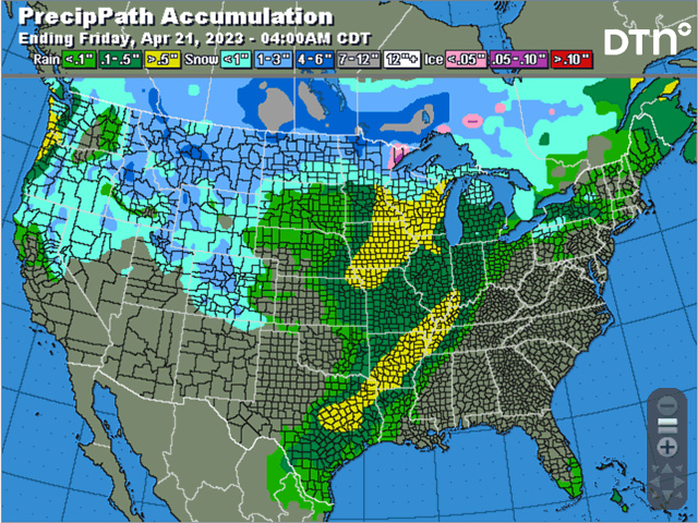
That system during the weekend produced areas of heavier rain, severe weather and heavy snow. The rain was blotchy, but fell over needed areas in eastern Kansas into parts of Iowa. Severe storms were numerous from Illinois to eastern Texas.
And the snow was heavy across Minnesota, Wisconsin, and Michigan. In fact, a band of 12-24 inches fell in western Wisconsin that will take some time to melt. The precipitation was accompanied by some breezy winds. Those winds that moved through drought areas of the southwestern Plains did more harm to soils that have been begging for good rain for months.
The active pattern will continue this week. A trough of low pressure is moving into the Western U.S. with several disturbances circling around the center of it. As the trough slowly moves through the country this week and weekend, the disturbances will create waves of showers and thunderstorms for a lot of areas of the country, along with some snow across the north.
Any heavy snowfall amounts are likely to occur either along the Canadian border or north of it. Saskatchewan and Manitoba are forecast by several models to see widespread areas of 12 to 20 inches of snow, slowing down fieldwork there as well. Farther south, the rain and thunderstorms could spark some areas of severe weather centered around Iowa and the eastern Plains April 19, then down the Mississippi Valley for April 20-21.
Severe weather is less likely during the weekend as the final system moves through across the East, but may still be possible, along with some snow potential for the eastern Midwest.
Winds with these disturbances moving through are still going to be elevated. The southwestern Plains drought areas are unlikely to see much precipitation out of this and winds will continue to blow dust and sand around the region, an unfavorable situation for winter wheat in poor condition.
Another aspect of the pattern will be the drop in temperatures behind the system. Being sourced from Alaska and northwest Canada, the cold air that follows will drop temperatures well-below normal. That is likely to lead to some frosts across the southwestern Plains April 21-23, but then follow through the Midwest April 23-25.
Winter wheat in the Plains has taken a beating, and the damage from frost may not be all that noticeable. But wheat in the Midwest has had very good conditions so far. A day of temperatures touching or slightly below freezing for an hour or two is not all that concerning, but three days of cold certainly would be. Models are mixed on just how cold it might get over the Midwest next week and there are other confounding features, including cloud cover, that could make this point moot.
For northern areas, that will mean a continued delay in draining of fields and warming of soils. Planting of spring wheat, barley, and oats are all behind closer to the Canadian border and should likely remain on that path for the rest of April. The colder air is forecast to stick around until May, when there is more hope that the weather turns quieter with warmer conditions. We will have to see what happens with the models, but the delays and slowdown for the 2023 crop year hopefully won't be too long.
To find updated radar and analysis from DTN, head over to https://www.dtnpf.com/…
John Baranick can be reached at john.baranick@dtn.com
(c) Copyright 2023 DTN, LLC. All rights reserved.

Comments
To comment, please Log In or Join our Community .