Ag Weather Forum
Canadian Prairies 2023 Growing Season Weather Outlook
As we go through the second half of April and get ready for the 2023 growing season in the Canadian Prairies, it is a good time to check out how this season might bear out.
First, we need to look at how the soil is doing going into the season.
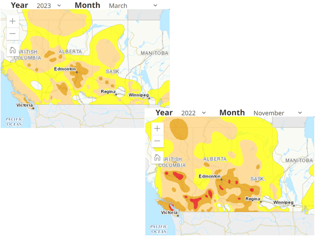
Last fall, drought became widespread and deep with very little reaching the ground going into at least November. Drought grew, covering most of Alberta and Saskatchewan west of Regina. Areas to the east fared a bit better. During the winter, it was a mix of mild and cold with several polar vortex-like cold shocks, and a good bit of snow.
Going into spring, March stayed an ice box as a trough of low pressure continually sat over western North America. The cold kept the snowpack from melting and instead, a couple of larger snow events caused the snowpack to grow.
It took into April for the warmth to return to the region and, during this past week, allow for substantial melting to begin. The warmth has been brief and still much of the region remains snow-covered outside of Alberta where warm winds coming down off the Rockies have been able to take significant chunks out of it.
P[L1] D[0x0] M[300x250] OOP[F] ADUNIT[] T[]
As recently as this week, most of southern Saskatchewan was also snow-free, but a storm system brought accumulating snow to this part of the region on Thursday night.
Despite this, soil moisture is not great across the region, and the snowpack that built up was generally near or below normal. But still, drought has been reduced across much of the southern half of the region as noted in the Canadian Drought Monitor. In contrast, some areas across Central Alberta, northern Saskatchewan, and Manitoba are in worse drought coverage and intensity than six months ago, a testament to the underlying dryness going into the 2023 growing season.
A return to a western North America trough is starting to set itself back up, and a cooler regime will be maintained for the rest of April.
For those wanting to get started planting by the first of May, that will likely be hard to accomplish. This setup does favor additional storm systems and added moisture, but mostly in the form of cold rain or snow.
There will likely be some warmer days mixed in, but the second half of April does not support any widespread fieldwork or planting action. That may also bleed into the beginning of May, but that is likely where that will end.
In a meeting with DTN Long-Range Weather Risk Analyst Nathan Hamblin, Hamblin noted that suggestions from a pattern of thunderstorms across the Equator, the Madden-Julien Oscillation, and a high-pressure system moving into eastern Asia will change the pattern around or after the May 10. Until then, he noted, we should expect a generally cooler pattern and one that could come with significant snow. However, that could be the end of the cold.
With El Nino building during the next couple of months, the prospect for a continued cold pattern well into May or June is unlikely. Models agree, but that does not mean that the pattern will flip to a hotter one, either. Instead, we should anticipate a return to average conditions during the summer. That means a typical pattern of thunderstorms developing off the Rockies and moving eastward, typical of what occurs in summer. Storm system should come at a regular pace, and episodes of heat will likely be limited in duration and intensity. They would still occur, but come at a less frequent pace throughout the summer.
An analysis of similar years in the past of a building El Nino during the summer point to variable conditions for the Canadian Prairies, though the presence of a western ridge may lead to some warmer days in Alberta than farther east. Should that occur, it would be the western Prairies that have a higher chance of heat stress, but also an extended growing season, which might be important should planting be delayed.
Overall, that would not be a bad situation as long as rains are frequent, as they are forecast to be. However, with the antecedent dry conditions across the region, areas that start missing those thunderstorms will be more danger of having production issues than those where it is more frequent. Even wetter areas could show stress if the excess cannot overcome the dryness.
The region is coming out of the poor conditions induced by La Nina during the past two years, but may take this third year to fully recover. The prospects for 2024, should El Nino develop this year, would generally be more favorable.
To find more international weather conditions and your local forecast from DTN, head over to https://www.dtnpf.com/…
John Baranick can be reached at john.baranick@dtn.com
(c) Copyright 2023 DTN, LLC. All rights reserved.


Comments
To comment, please Log In or Join our Community .