
Ag Weather Forum
Blizzard, Strong Winds, Severe Storms Hitting Plains, Canadian Prairies, Midwest
After a strong storm system brough widespread heavy rain, severe weather, and a band of intense snow across the Midwest March 24-25, another system did so March 31 to April 1. That included the most significant severe event of the year so far, where over 100 tornadoes were reported along with a total of more than 1,300 combined severe hail, wind, and tornadoes. A third one moves through over the next couple of days with similar impacts, but this one will likely be remembered for its snowfall.
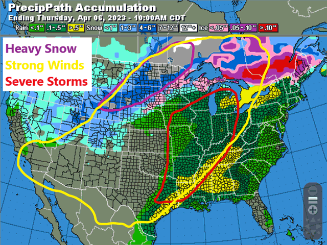
The first two storms did end up producing bands of moderate to heavy snow. The first from eastern Iowa through Michigan and several locations ended up close to a foot of the white powder. The second, from South Dakota through the Upper Peninsula of Michigan, did the same. But the coming storm is likely to double those amounts. The storm is currently spinning in the Rockies on April 3 and will emerge into the Plains on April 4. A band of showers has already started to develop across Wyoming and southern South Dakota on Monday afternoon. That band will intensify Monday night and spread through the Northern Plains, northwest Minnesota, and the eastern Canadian Prairies for April 4-5. Snow will wind down from southwest to northeast Tuesday night through Wednesday night. Snowfall totals are likely to be variable due to changing temperatures and banding within the shield of snow. But widespread amounts of 8 to 15 inches are expected (20 to 38 cm) to fall across the area that includes most of the Dakotas, northwest Minnesota, and eastern Manitoba where the snowpack continues to be very thick. Around Wyoming and the Black Hills of South Dakota, amounts are likely to exceed 24 inches (60 cm) and there could be some areas in the snowband that pick up amounts in that 15 to 24 inches (38 to 60 cm) range as well. Coupled with increasing winds getting into the 50 to 60 mph (80 to 100 kph) range Tuesday evening, and especially on Wednesday as the system wraps up, blizzard conditions are likely to develop.
P[L1] D[0x0] M[300x250] OOP[F] ADUNIT[] T[]
During calving season, the heavy snow is likely to stress cattle out in open areas and drifting may bury animals that try to take refuge in ditches, shielded from the wind. The added snowpack will take longer to melt as we get further into the spring season.
To the south, winds will whip up across the Plains and invoke more blowing dust. Gusts are likely to exceed 60 mph and could hit upwards of 80 mph from west Texas and western Kansas west to the southern Rockies. An area that has been battered by intense windstorms for weeks will continue its curse upon a winter wheat crop that is struggling to survive. The area will again by bypassed by rains as it stays dry.
Those rains should start up as the cold front to the system makes it to the eastern edge of the Plains. From Iowa down through northeast Texas, bands and individual cells are expected to ignite from Tuesday afternoon through Tuesday night. These storms will be very capable of producing tornadoes, damaging wind gusts, and large hail. The threat shifts through the Midwest and down into the Delta on Wednesday, though the intensity of these storms is not expected to be as great as the ones that occur on Tuesday. This area suffered greatly with the last round of severe weather on March 31. Another round could be devasting to those who get hit twice within a five-day stretch.
If there is any good news out there, it appears that this will be the last of the long chain of strong storms that has moved through rather rapidly since November. The weather pattern for next week includes quieter conditions and a warmup that could start the snowmelt in the Northern Plains and Canadian Prairies
To find updated radar and analysis from DTN, head over to https://www.dtnpf.com/…
John Baranick can be reached at john.baranick@dtn.com
(c) Copyright 2023 DTN, LLC. All rights reserved.

Comments
To comment, please Log In or Join our Community .