

Ag Weather Forum
Winter Brought Definite Midwest Drought Relief

As the weather calendar moves from the winter months of December-January-February to the spring season of March-April-May, a look at the impact of the 2022-23 winter season precipitation shows some notable drought relief in the Midwest.
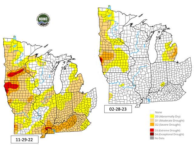
The U.S. Drought Monitor breakout for the Midwest region at the end of November 2022 showed that almost 74% of the region was in some phase of drought. Only the immediate Great Lakes areas, along with a portion of the upper and central Mississippi Valley, along with eastern Ohio, were drought-free. In addition, extreme drought (D3 on the drought monitor) was in effect in much of northwestern Iowa and a swath of south-central Minnesota.
But, a look at the Midwest Drought Monitor as of the end of February shows a much different set of drought conditions. The entire Mississippi Valley and almost all the Ohio Valley are now drought-free. The extreme drought swath in Minnesota is mostly tagged as "abnormally dry". In Iowa, extreme drought is now in effect only in an area adjacent to Sioux City on the Missouri River. Generally speaking, drought in the Midwest at the start of spring 2023 is concentrated in only three states -- Minnesota, Iowa and a portion Michigan. More than 77% of the Midwest is assessed as drought-free on the doorstep of this spring season.
P[L1] D[0x0] M[300x250] OOP[F] ADUNIT[] T[]
Precipitation over the winter looms as a direct cause of this change in the drought picture. During December-January-February, precipitation in Iowa, Minnesota and Wisconsin ranged from 125% of normal to 300% of normal -- in other words, the top end of precipitation accumulation was three times the normal winter precipitation total. Elsewhere in the Midwest, the winter precipitation was not quite as heavy, but was still enough to change the drought picture considerably. Amounts ranged from 75% of normal to 150% of normal, according to the Midwest Regional Climate Center.
The U.S. Drought Monitor summary for the Feb. 28 update noted the wet winter, along with additional benefit from winter moisture in drier areas that is yet to be realized.
"This has been a particularly wet winter for the Upper Midwest. But previous months, especially last summer, were dry and hot, which dried the soils. As winter set in, the soils froze and the dry condition was locked into place. The soils in the Upper Midwest are still frozen, so the benefits of the recent precipitation, which is laying as a deep snow cover, won't be realized until the soils thaw and the snow meltwater soaks into the ground," the Monitor's summary noted.
Winter season drought easing is not unheard of, but it is unusual given that winter tends to be a drier season. But the storm tracks stayed in place over the Midwest, and the drought assessments are showing both benefit along with improved prospects for starting crops out later this spring when planting gets underway.
Bryce Anderson can be reached at Bryce.Anderson@dtn.com
Follow him on Twitter @BAndersonDTN
(c) Copyright 2023 DTN, LLC. All rights reserved.
Comments
To comment, please Log In or Join our Community .