

Ag Weather Forum
What Happens Now With La Nina Fading into Spring?

Sea-surface temperatures in the tropical Pacific Ocean are rising. That is normal for this time of year. The natural cycle of ocean temperatures in this part of the globe follows a typical pattern of coolest in Northern Hemisphere fall and warmest in the spring, so absolute temperatures should be rising anyway. But the ocean temperatures are rising faster than normal, trying to get to where they should be for this time of year.
Since Northern Hemisphere fall of 2020, ocean temperatures have been lower than normal, giving rise to what is known as La Nina. When temperatures are higher than normal, it is called El Nino. Temperatures typically oscillate between the two conditions on the timescale of several months.
El Nino and La Nina are two sides of the same coin, referred to as the El Nino Southern Oscillation (ENSO) and have profound effects on world-wide weather patterns.
The heat distribution in the ocean changes the energy balance equation. When more heat is directed toward Indonesia and Australia (La Nina), more energy is distributed not only to these areas, but also poleward, which disrupts the jet stream. The same is true during El Nino, when the higher concentration of heat is toward the middle of the Pacific, thunderstorm patterns change and energy is sent through different areas of the globe. With how large the Pacific Ocean is, ENSO ends up being the largest known driver of world-wide weather patterns on a seasonal basis. Tracking ENSO conditions is the most important way to understand long-range weather patterns.
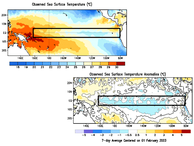
Sea-surface temperatures are tracked based on how close to average they are, which is calculated over the last 30 years of data. Small differences from the average mean big changes for global weather. The process for changing sea-surface temperatures is slow. Afterall, ocean currents travel at about 10-20 miles per day, so getting across the vast ocean of 8000-9000 miles can take more than a full calendar year.
P[L1] D[0x0] M[300x250] OOP[F] ADUNIT[] T[]
During the last few weeks, sea-surface temperatures in the Pacific Ocean have been rising and getting back to neutral conditions, but La Nina has persisted. Climate scientists in different countries use different standards and metrics to determine which phase on ENSO we are in. For instance, U.S. Climate Prediction Center uses a threshold of 0.5 degrees Celsius (0.9 degrees Fahrenheit) over a three-month period to make its determination. The Bureau of Meteorology in Australia uses a combination of sea-surface temperatures, wind speeds, and pressure to determine it.
In regard to the U.S. metric, the ocean waters recently hit an important milestone. On the last weekly average, sea-surface temperature anomalies were at minus 0.5 degrees C after months of hovering around a minus 1 degree C from late 2021 through most of 2022. Though the weekly numbers are pushing the ocean toward the neutral status, the monthly average is still below minus 0.5 degrees C. The trend follows what forecasts have been saying for months, in that we should be getting out of La Nina and into neutral conditions in the late winter and early spring.
There are other indicators that suggest La Nina is weakening as well. Looking below the surface, the pool of cool waters has been slowly eroding over the last few months. This is part of the reason why sea-surface temperatures have been rising. Another indicator looks at the upwelling and downwelling waves moving through the ocean. Downwelling waves push colder waters below the surface down and leading to rising sea-surface temperatures. Upwelling waves are the opposite. There was a downwelling wave that went through the Pacific in November and December and started the warming process. Another wave is currently being analyzed near the International Dateline in the middle of the ocean, which will help to erase more of the cooler waters over the next few weeks. That supports forecasts for continued ENSO-neutral conditions through the Northern Hemisphere spring.
Though getting into neutral conditions means the waning influence of La Nina, it takes the atmosphere several weeks to respond, meaning that La Nina will still control the weather patterns for the next few months, an ominous sign for those who have winter crops in drought across the southwestern Plains.
Looking farther into the future, climate models from all around the world agree that ocean temperatures should continue to rise through Northern Hemisphere summer. Models disagree on the amplitude, but many of them reach the threshold for El Nino in the Northern Hemisphere mid-summer or early fall.
For crop production in the United States, a transition out of La Nina and into El Nino during the spring and summer typically leads to variable temperatures, but a "normal" rainfall pattern. That includes some winners and losers, but most areas between the Rockies and Appalachians end up with enough rainfall to make a crop.
With this being the third-straight winter where La Nina is in control, a phenomenon that has only been confirmed three times in the last 75 years, there may be additional consequences that are unknown, but signs still point to overall good corn and soybean yields. My colleague Bryce Anderson wrote about that here: https://www.dtnpf.com/….
If you will be in Louisville, Kentucky for the National Farm Machinery Show, I will be giving a more detailed look at what the change in ENSO may mean for U.S. farmers and ranchers along with my colleague DTN Lead Analyst Todd Hultman, who will give an outlook on the markets. Come visit and say "hi"! We will be speaking each day of the show.
To find updated radar and analysis from DTN, head over to https://www.dtnpf.com/…
John Baranick can be reached at john.baranick@dtn.com
(c) Copyright 2023 DTN, LLC. All rights reserved.
Comments
To comment, please Log In or Join our Community .