
Ag Weather Forum
Arctic Air Returning to Canada's Prairies Next Week
Temperatures during this week have risen above normal in the Canadian Prairies. The heat continues through the rest of the week, but a change in the weather pattern will bring back the arctic cold that occurred in earlier November.
The recipe for bringing cold, arctic air to the Canadian Prairies is an upper-level trough of low pressure either directly overhead or off to the east while an upper-level ridge of high pressure builds across Alaska. Earlier in November, that occurred for about 10 days. Temperatures were 10 to 20 degrees Celsius (18 to 36 degrees Fahrenheit) below where they should be for several days in a row, compounded by increasing snowpack, which limits the moderating of those temperatures.
P[L1] D[0x0] M[300x250] OOP[F] ADUNIT[] T[]
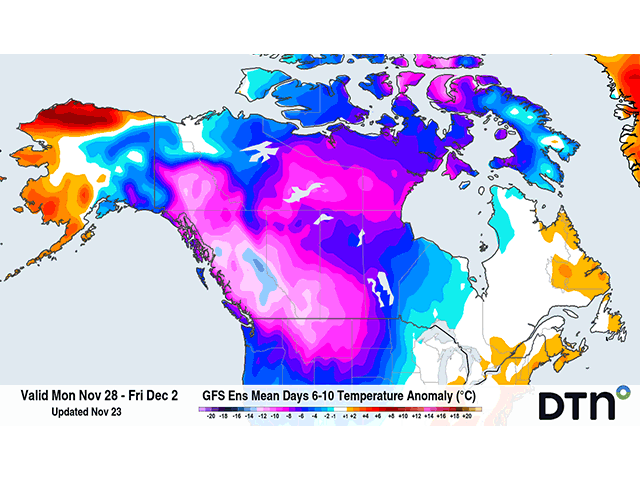
During the last several days, we saw that trough move over to Quebec and Labrador while the upper-level ridge spread more through the region. That is increasing temperatures this week and readings are going back above the freezing mark in a lot of the region. Some readings of 10 C (50 F) will be possible in southern Saskatchewan and Alberta Nov. 25.
But the heat will not last very long. The absent trough will regain a hold of the region starting Nov. 26 and a building ridge in Alaska will assure that polar air dives into the region over the weekend. Light to moderate snows could add up to 8 to 15 centimeters (roughly 3 to 6 inches) over the northern reaches of the region, which will help to build the lower temperatures. It may not be constantly cold all of next week, and Manitoba is likely to be at least a bit warmer than areas to the northwest, but readings of 10-20 degrees C below normal could move back into the region at times during the week. The end of the week looks coldest as December begins and the pattern for the first half of December also looks to continue the trend for below-normal winter temperatures.
To find more international weather conditions and your local forecast from DTN, head over to https://www.dtnpf.com/…
John Baranick can be reached at john.baranick@dtn
(c) Copyright 2022 DTN, LLC. All rights reserved.

Comments
To comment, please Log In or Join our Community .