

Ag Weather Forum
Southeast US Farmers Prepare for Hurricane Ian

It has been a slow hurricane season so far. Many forecast centers were anticipating an above-average year for the number of hurricanes in the Atlantic basin due to La Nina and warm ocean temperatures. An average hurricane season in the Atlantic results in about 14 named storms, seven hurricanes, and three major hurricanes (Category 3 or higher). Most centers were expecting 18 to 20 named storms, seven to 10 hurricanes, and four to five majors. With Ian now reaching major hurricane strength as it crossed over western Cuba Tuesday morning, the totals so far this year are nine named storms, four hurricanes, and two majors. With only two months left to go, and a historical downtrend in frequency, it seems the number of storms is likely to be below forecast -- though there is time to meet expectations.
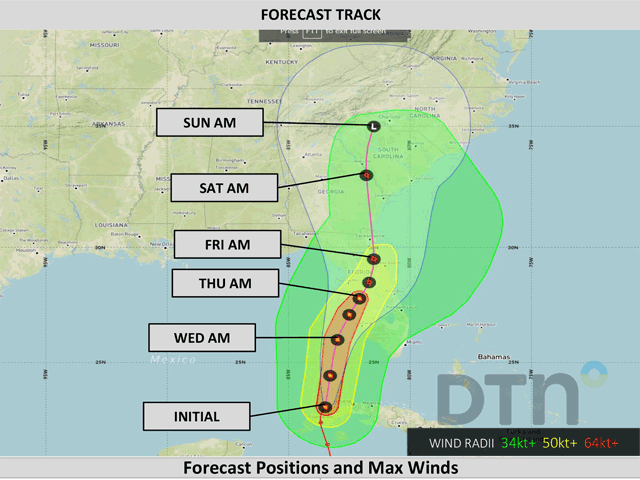
But those who live in the Southeast U.S. are not concerned with the number of tropical storms right now. Their focus is on one storm -- Ian. As of 11 a.m. EDT Tuesday, Hurricane Ian was moving off the coast of Cuba and into the warm waters of the Gulf of Mexico with maximum sustained winds of 115 mph (Category 3 on the Saffir-Simpson scale). The storm track has been waffling with a coastal impact around the Gulf Coast of Florida since late last week. The track now seems headed toward the central Peninsula. The current forecast from DTN has the storm on track to make landfall around or just south of the Tampa metro Wednesday night or early Thursday morning, though there is some variation in the forecast track. With the storm moving somewhat along the coast instead of right at it, a small change in the track could mean a large change in the landfall location, as well as the exact timing. The exact location of landfall is not as important as there should be widespread impacts up and down the coast of Florida.
As far as intensity, bathwater-like temperatures in the Gulf of Mexico will fuel the storm and it is expected to reach Category 4 strength Tuesday. Some increasing wind shear and drier midlevel air will counteract the warm waters to potentially weaken it some before landfall in Florida. But the storm is still expected to be at Category 3 strength when it crosses the coast.
P[L1] D[0x0] M[300x250] OOP[F] ADUNIT[] T[]
The wind impacts will be most devastating right near the coast at landfall, as the strongest winds in the eye tear into buildings, trees, and powerlines. Storm surge is expected to reach five- to 10-feet above sea level, flooding the coastline. The storm should quickly weaken after landfall due to land-interaction and the increasing wind shear and dry air. But that does not mean those outside of Florida do not need to worry about the system.
As the storm center weakens, the rains will actually increase. A front situated over Florida will help to focus rainfall as the storm system moves northward. Citrus groves in the state are likely to receive heavy rainfall. Widespread amounts across the state of four to six inches are expected. However, near the track of the storm, rainfall amounts may exceed 12 inches along with potential for more than 24 inches in a more-localized zone over the northern Peninsula.
As the storm heads into Georgia on Friday, the heavy rain will push out ahead of it, covering the Carolinas and eventually Virginia with bouts of heavy rain as well. Cottonfields in Georgia are still maturing and only 3% of fields have been harvested according to the USDA NASS Crop Progress report. Cotton is mostly in good shape and farmers may try to make more significant progress this week before the heavy, flooding rains come in. While not as impressive as in Florida, amounts of two to six inches are forecast across the state. Rain could be heavier if the center stalls out in the state. Similar amounts are expected in the Carolinas with more variability over Virginia. Corn is already 74% harvested in North Carolina, with 94% of it mature. Soybeans are much further behind at only 10% harvested with just 52% dropping leaves. With heavy rain potentially causing damage, we are likely to see much more of the crop being harvested this week in anticipation of the rains coming Friday and Saturday. But not all crops will be harvested in time. Damage is likely to occur.
There is another weather risk and that is tornadoes. While winds may not be as damaging away from the storm center, the risk of tornadoes increases on the eastern side of the storm, which may cause localized wind damage. This threat is maximized over Florida but could move into Georgia and the Carolinas on Friday and Saturday as well.
The storm system will meander in the Southeast through the weekend before pushing offshore early next week. While the storm should make for incredible damage in Florida, heavy rain in the Southeast will also drive actions for producers to get out and harvest and make plans for flooding all week long.
To find more regional weather conditions and your local forecast from DTN, head over to https://www.dtnpf.com/…
John Baranick can be reached at john.baranick@dtn.com
(c) Copyright 2022 DTN, LLC. All rights reserved.
Comments
To comment, please Log In or Join our Community .