

Ag Weather Forum
August Weather Forecast Reminiscent of July
A brief break in the summertime hot-and-dry pattern is settling in this week with a couple of cold fronts bringing cooler air from Canada along with periods of showers. The southern Corn Belt is enjoying widespread rainfall the morning of July 26 and it is heavy in some spots. A few of these locations are still in some category of drought.
Farther south across southern Missouri, Oklahoma, Texas, portions of Kansas, and most of the Delta, July has been a horrible month. Widespread heat with temperatures regularly eclipsing the 100-degree Fahrenheit mark and an almost complete lack of rain have increased drought dramatically. A three-class degradation in drought conditions has occurred for stretches of the region over the month. Some of these places are set to see some good rainfall through this coming weekend, but the drought has certainly taken its toll on crop conditions and damage likely has occurred.
P[L1] D[0x0] M[300x250] OOP[F] ADUNIT[] T[]
Selected states on the USDA's Crop Progress report as of July 24 show all the southern states I mentioned above have good-to-excellent corn ratings at 39% or lower. Missouri is the exception at 53% good to excellent as northern parts of the state have actually had very good rainfall so far this year to balance it out. A similar trend is found in soybeans, but August is the month to make or break that crop, so the concerns have not piled on quite as high just yet as they have for corn.
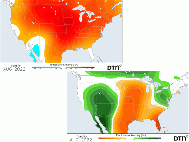
Rains across these southern areas will be a blessing, but unfortunately for producers, they will not be sustained. A ridge of high pressure that had been across the middle of the country for most of July has split into two pieces, one in the Southeast and another in the West. In between, a trough has developed to bring in cooler air and bouts of showers. The portion of the ridge in the West is very strong and that will spread eastward across North America starting this weekend and continue through next week. Long-range models suggest there will be little break in the pattern through all of August. Like most areas in July, the ridge across the middle of the country should lead to higher heat across most of the country's growing regions and also drier conditions, relatively speaking. The overall effect for filling corn and pod-filling soybeans in the country should point to reduced yields.
However, that should not mean doom and gloom for all areas. Ripples on the northern edge of the ridge will allow for storm systems to move through Canada and their fronts will pass through the northern half of the U.S. With the high heat and humidity in place, there will be plenty of fuel to produce showers and thunderstorms at times. Though, with much of the upper-level energy to organize storms north in Canada, the showers that pass through the U.S. are likely to be scattered and weaker. Localized areas may get enough rainfall at the right time to make for decent yields, but there are more areas than not that will be too hot and dry and should see their crop conditions sliding throughout the month.
One caveat to this forecast is the potential for another disturbance to move through around the middle of the month similar to the one going through the North-Central U.S. this week. Thunderstorms associated with the Madden-Julian Oscillation (MJO) that are moving around the equator have a tendency to affect the weather in North America depending on where they are located. The location of a wave of thunderstorms moving through northern South America is forecast to return to the same location around Aug. 10-15. The upper-air forecast over North America around that same time does have a trough moving through Canada at the same time. If that trough is a bit stronger, we could see cooler temperatures and more consistent rainfall moving through more of the Corn Belt, perhaps like we are seeing this week. Both the European and American extended models do show some sort of small flare up, or at least a trend away from dryness during the middle of the month across the Corn Belt, but nothing on the scale of what we are currently seeing. Models at that range cannot accurately depict localized areas of rainfall anyway, but there is at least a chance for increased precipitation for a short time period and potentially cooler temperatures. Unfortunately, like this current break in the pattern, the one that may come mid-August would also be short-lived. Between the breaks, the heat is likely to be intense, especially for those over the southern Corn Belt, Southern Plains, and much of the Delta. Despite a bout of relief coming this week, these areas should continue to have poorer weather conditions for the month of August.
To find more regional weather conditions and your local forecast from DTN, head over to https://www.dtnpf.com/…
John Baranick can be reached at john.baranick@dtn.com
(c) Copyright 2022 DTN, LLC. All rights reserved.

Comments
To comment, please Log In or Join our Community .