

Ag Weather Forum
Change in Weather Pattern for Next Week Favorable, but Fleeting

Heat has been relentless in the Central and Southern Plains during the last several weeks and at times has been spreading north and east. This week, the heat has been surreal for a lot of folks. An area from southern Kansas through northern Texas reached highs around or exceeding 110 degrees Fahrenheit on July 19. For Wichita, Oklahoma City, and Dallas, high temperatures have not dipped below 90 F all month long. Temperatures have been at or above normal each day for at least the month of July. And for Dallas, that goes back through most of June as well.
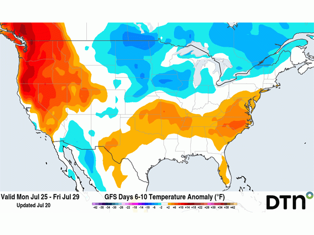
Although it is likely to be temporary, we are going to see a big change in the upper-air pattern next week. A ridge that has been almost ever-present across the West and into the Central and Southern Plains, the cause of the heat, is going to split into two pieces. One will situate itself over the Southeast, though it will be somewhat weak. The other piece will be stronger on the West Coast.
It is that second ridge in the West that will be the driver of a trough to move from Alaska into the middle of North America next week. Ridges are notorious for hot and dry conditions. Those will certainly be the case in the Pacific Northwest. Wheat is still heading and vulnerable to hot and dry conditions, though much of the region still has good crop ratings and adequate soil moisture to withstand a hot spell. Rainfall has been awfully weak for weeks and soil moisture has been slowly falling in the region. The incoming heat should accelerate that process.
East of the Rockies, temperatures in the Plains will fall. Above-normal temperatures will fall to near or below normal for a lot of areas and certainly through the majority of the Corn Belt. In addition to the reduction in temperatures, frontal boundaries will press through the region. With the high heat and humidity in place ahead of such fronts, there is plenty of fuel for thunderstorms to occur, a welcome occurrence for farmers in the Heartland.
That process starts in a sense this weekend. One disturbance will bring showers through the Corn Belt and some below-normal temperatures are forecast to move into the Northern Plains. But a much stronger front will sweep through more of the country next week. Widespread showers and thunderstorms are expected to result from that front moving through.
P[L1] D[0x0] M[300x250] OOP[F] ADUNIT[] T[]
The ridge in the Southeast will oppose its progress and the front will likely stall out somewhere from the Southern Plains through the Tennessee or Ohio Valley. Showers may be a little more consistent in this area if the front stalls, bringing more widespread precipitation to areas that severely need it. Drought has had a constant presence in the Southern Plains in 2022 and has grown recently in the Delta and portions of the Eastern Corn Belt.
That comes at a time when corn is pollinating -- a stressful situation for its development. Rains coming next week may not be able to save all corn, or other crops for that matter, but would certainly ease stress and reduce further reduction in soil moisture.
The only problem is that this situation is not permanent, just a bit of a blip in the continued pattern of hot and dry that has been the theme of the summer thus far. According to DTN Long-Range Weather Risk Communicator Nathan Hamblin, the relief that the middle of North America will see next week will not last very long, just a few days.
Instead, a wave of thunderstorms moving east across the tropics, a result of the Madden-Juilan Oscillation (MJO), is going to change back in the beginning of August. Hamblin noted that "the wave that is moving through the eastern Pacific will quickly head through the Americas and into Africa next week, causing the change in the upper-air pattern, but then move back into the Indian Ocean at the beginning of August."
When it does, Hamblin said, we should get right back into the pattern we have been in with a Central U.S. ridge. Or in other words, the heat will be coming back to the Central and Southern Plains and probably extend farther north and east again for early August.
He does note that models continue this wave along the equator through the middle of August. "If it holds together passing through the Eastern Pacific and into Central and South America again, then another bout of relief should come with it to the central U.S. That is forecast to occur around Aug. 10, followed by another trip into the Indian Ocean and another round of Central U.S. heat a few days later."
But we should not expect a copycat response at that time. Every wave is different and this one may not be as strong. Previously, this wave was not expected to be this strong either, and only make for a weak trough moving through Canada instead of extending down into the central U.S. This one coming up may affect mostly Canada instead.
Timing could also be a bit off, as models are usually a little fast or a little slow on when this occurs, and there is some disagreement on the timing between those models as well. But overall, we should expect bursts of heat to keep coming through the U.S. at times for the rest of the summer.
The hope is that these brief breaks and relief bring enough showers to enough producers at the right time to make for a decent crop. Otherwise, the heat and relative dryness will continue to stress more and more of the country for the remainder of summer.
To find more regional weather conditions and your local forecast from DTN, head over to https://www.dtnpf.com/…
John Baranick can be reached at john.baranick@dtn.com
(c) Copyright 2022 DTN, LLC. All rights reserved.
Comments
To comment, please Log In or Join our Community .