Ag Weather Forum
La Nina to Continue Through 2022 Growing Season
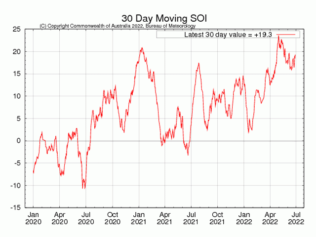
La Nina will not go away. The cool-water phase of the equatorial Pacific Ocean temperature and atmospheric pattern is now in its third year, and summer 2022 shows the strongest La Nina atmospheric measurement of this multi-year run for this point in the year.
The atmospheric component of La Nina is noted by the Southern Oscillation Index, which is usually referred to as the SOI. The SOI tracks the relationship in barometric pressure between the island of Tahiti in the central Pacific Ocean and the city of Darwin in the Northern Australia Territory. A post from NOAA's climate.gov explains that the SOI "compares the difference from average air pressure in the western Pacific, measured in Darwin, Australia, to the difference from average pressure in the central Pacific, measured at Tahiti...During La Nina (positive SOI), the pressure is higher than average over the central Pacific near Tahiti, and lower than average over Australia. During El Nino, the SOI is negative, and the anomalies are reversed."
The Pacific circulation numbers are definitely in the La Nina phase. The 30-day SOI moving average as of June 30, 2022, was plus 19.3. That value is considerably higher than in late June of either 2021 or 2020 when the SOI value was around plus 2.0.
P[L1] D[0x0] M[300x250] OOP[F] ADUNIT[] T[]
La Nina during the U.S. growing season is a challenging crop weather maker for corn going into pollination--which is still ahead for the majority of the corn crop. When La Nina is in effect, upper-atmosphere high pressure tends to be the dominant feature during the midsummer period. That upper-atmosphere high is, in turn, a pattern that brings drier and hotter conditions to the central U.S. If soil moisture is short when the dry and hot pattern sets in, corn pollination can be affected, and lower yield is possible.
Prospects for this kind of stressful heat and dryness when La Nina features are dominant in the Pacific make the time frame during the first week of July very important. Late-week forecast maps show daily chances for shower and thunderstorm activity for much of the western and northern Midwest with total rainfall of more than 1.5 inches. This would be very useful moisture as corn goes further into pollination and soybeans approach the blooming and pod-setting stages. However, forecast models have a tendency to overstate the precipitation totals, so actual rainfall amounts by July 6-July 7 will garner plenty of attention.
Details on developing Midwest flash drought concerns are available here:
The full NOAA La Nina explanation article is available here: https://www.climate.gov/….
Bryce Anderson can be reached at Bryce.anderson@dtn.com
Follow him on Twitter @BAndersonDTN
(c) Copyright 2022 DTN, LLC. All rights reserved.


Comments
To comment, please Log In or Join our Community .