
Ag Weather Forum
Drought Growing, Shrinking as we Approach Spring
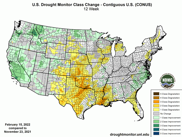
It had a lot to do with the outcome of the 2021 crop, but drought will again be the largest concern for the 2022 crop as well. And that is because as of Feb. 15, 72.6% of the lower 48 states is in some category of drought according to the U.S. Drought Monitor. That includes 11.9% of the country in the highest two categories of drought.
Much of the drought is situated over the western half of the country, including large wheat areas in the Pacific Northwest and throughout the Plains. But those western states also produce a lot of corn and soybeans. Even in the drought-affected areas last year, the states of North and South Dakota, Nebraska, and Kansas produced over 23% of the total corn crop and over 20% of the total soybean crop based on the latest numbers from USDA. Sure, the drought in Nebraska and Kansas came on late in the season, so the drought did not have as much of an impact in these two states as in the Dakotas. But the area affected by drought in 2021 also included much of Minnesota and parts of Iowa, northern Illinois and southern Wisconsin. Drought remains in these states as well. These are much higher production areas of the country for corn and soybeans, so all three crops are under the influence of drought going into planting season.
La Nina sure has played a large part in the ongoing drought situation over the winter. La Nina typically leaves the Central and Southern Plains on the dry side of normal and that certainly has been the case. Since Nov. 23, drought has expanded for most of the Plains from Nebraska southward. For central Kansas down through central Texas, that expansion has resulted in 3 to 4 classes of drought degradation. Dryness has also spread across the southern half of the Delta region, again typical of La Nina conditions.
P[L1] D[0x0] M[300x250] OOP[F] ADUNIT[] T[]
Across the North-Central U.S., there is little signal that La Nina plays a significant role in precipitation amounts. Indeed, we have seen mixed conditions. Portions of South Dakota, Iowa, northern Illinois, Wisconsin and lower Michigan have seen degrading drought conditions over the last three months. But also, we have seen some areas of improvement for Montana, North Dakota, northern Minnesota and into the Upper Peninsula of Michigan. Here, clippers have been very persistent since late December. While the systems themselves have run right across the North-Central U.S., they also come with mostly light precipitation. Where the systems have been the most consistent, farther north, they have led to drought improvement. But where they have been less consistent, farther south, we have seen drought worsening. But outside of a section around the eastern Dakotas into southwest Minnesota, much of this area remains in some category of drought.
Another feature of La Nina is increased precipitation in the Pacific Northwest. That has also been a feature, but mostly in the month of December, which included the Southwest as well. Drought conditions have vastly improved for much of these regions over the winter, though it remains a threat. The last several weeks in the clipper pattern have left much of the West rather dry compared to normal and the worry is that continued dryness could swing momentum back into drought building instead of drought reduction.
The last impact that La Nina has is to favor increased precipitation across the Ohio Valley region. A couple of storm systems earlier in February and a couple more coming up over the next couple of days certainly point to that effect. There is no drought coverage in Indiana, Ohio, Kentucky, or Tennessee, and large portions of Illinois are also drought free. Large portions of Missouri and Lower Michigan are only in the D0 (abnormally dry) category, which may be wiped out with the precipitation from last week or this week, putting a large portion of the country's primary growing region in above-normal soil moisture going into spring. With little to no drought in the fall, the increased precipitation has only acted to maintain soil moisture in these areas and keep the dry-west and wet-east pattern from last year intact heading into the coming year.
Whether increasing or decreasing, drought continues to be the major weather concern going into the 2022 season and will likely have an impact on spring planting across a vast area of the country.
To find more regional weather conditions and your local forecast from DTN, head over to https://www.dtnpf.com/…
John Baranick can be reached at john.baranick@dtn.com
(c) Copyright 2022 DTN, LLC. All rights reserved.

Comments
To comment, please Log In or Join our Community .