

Ag Weather Forum
Wide Variance in Corn Belt Soils Late-Winter Moisture

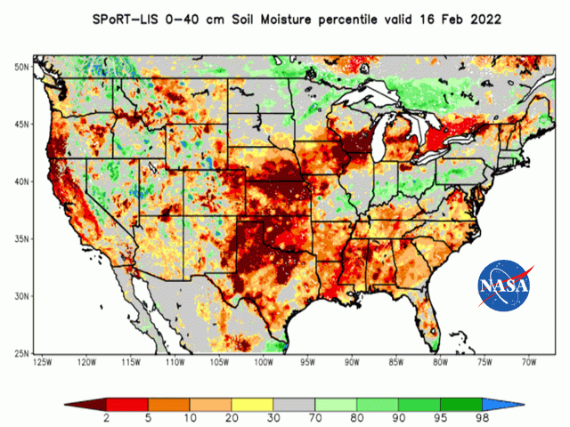
Soil moisture ahead of the 2022 row crop season has no middle ground. A detailed look at satellite imagery analysis of the top 16 inches of the soil profile shows either dry or wet. This article deals with analysis done by the National Aeronautics and Space Administration (NASA) Short-term Prediction and Research Transition project (SPoRT), headquartered at NASA's Marshall Space Flight Center in Huntsville, Alabama.
The SPoRT project produces many analysis products, including a look at the moisture in the soil profile from the surface to 40 centimeters (about 16 inches) below the surface. This is an important metric; the bulk of a corn plant's root mass is located in that 16-inch layer.
As of mid-February, the analyzed top 16-inch layer of the soil profile had soil moisture percentile rankings of no higher than the 20th percentile in the northern and western Corn Belt, including Michigan; Wisconsin; northern Illinois; southern Minnesota; Iowa; northern and western Missouri; most of South Dakota; Nebraska; eastern Colorado; Kansas; Oklahoma; and Texas. These low percentile rankings are also widespread in the Delta and Southeast.
P[L1] D[0x0] M[300x250] OOP[F] ADUNIT[] T[]
In contrast, the situation is much different -- and wetter -- in the remainder of Illinois and Missouri along with the states of Indiana and Ohio. In these states and areas, the top 16 inches of the soil profile contain moisture is in the 80 to 90 percentile -- indicating wetter conditions. That wetter indication is also showing up in the remainder of Minnesota, northeastern South Dakota and the Red River valley in North Dakota.
The track of a winter storm system across the United States during mid-February appears to have added to the sharp precipitation/moisture divide. The bulk of the storm's rain, ice and snow occurred in a swath from central and southern Missouri through the Ohio Valley, but not in drier areas further north and west.
Forecasts through the next 30 to 90 days offer little change in this wet-dry demarcation. Monthly outlook updates issued by various weather and climate agencies extended the current Pacific Ocean La Nina into the April-May-June time frame, with the Pacific equatorial temperature now not expected to ease to Neutral until the May-June-July period. With this expected La Nina influence, spring precipitation forecasts place above-normal precipitation (and flood risk) in the Ohio Valley-eastern Midwest region -- where, already, precipitation has been most prominent. In contrast, the drier crop regions from the western Great Lakes west and southwest have mainly below-normal precipitation in store, except for the Red River valley. In addition, updated drought development forecasts call for drought to form in the upper Mississippi Valley in eastern Iowa-western Wisconsin-northern Illinois.
So, barring a substantial change in the precipitation pattern, spring planting 2022 faces concerns on either the too-dry or too-wet end of the spectrum. Happy-medium areas are few and far between.
Bryce Anderson can be reached at Bryce.anderson@dtn.com
Follow him on Twitter @BAndersonDTN
(c) Copyright 2022 DTN, LLC. All rights reserved.
Comments
To comment, please Log In or Join our Community .