Ag Weather Forum
Polar Vortex Round Two Setting Up
For those living in the Canadian Prairies and far northwestern U.S. Plains, the last several days have been a real slap in the face, reminding us that it is the winter season. Temperatures have fallen to 20 to 30 degrees below zero Fahrenheit (minus 28 to minus 35 Celsius) and in some spots a bit lower than that. The polar vortex arrived late last week and has been stuck across Western Canada since then, with cold weather starting to leak southward into the Northern Plains this week.
There is major resistance in the upper levels of the atmosphere. Ridges of high pressure across the southern U.S., Greenland, and North Pacific have kept this blob of arctic air relatively locked in place and will continue to do so for the rest of the week.
That southern ridge is the main culprit for keeping the cold from spreading very far into the U.S. In fact, it has brought abnormally high, perhaps tropical temperatures into the southern U.S. Temperatures are running some 20 to 30 degrees F (11 to 17 degrees C) above normal and will continue to do so for the next several days.
P[L1] D[0x0] M[300x250] OOP[F] ADUNIT[] T[]
But the ridge will not last forever. It is forecast to weaken this weekend and that will allow that built up energy in the West to quickly advance eastward through the country. Temperatures will moderate as it moves east, but it will quickly push those anomalously high temperatures out of the South for a day or two. Its movement will be too quick to sustain the cold for a significant length of time. Instead, a ridge will pop back up across the middle of North America early next week. Those that saw significant cold in Canada and the Northern Plains will see a reprieve from the arctic cold. But that, too, will be brief.
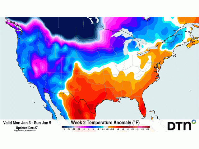
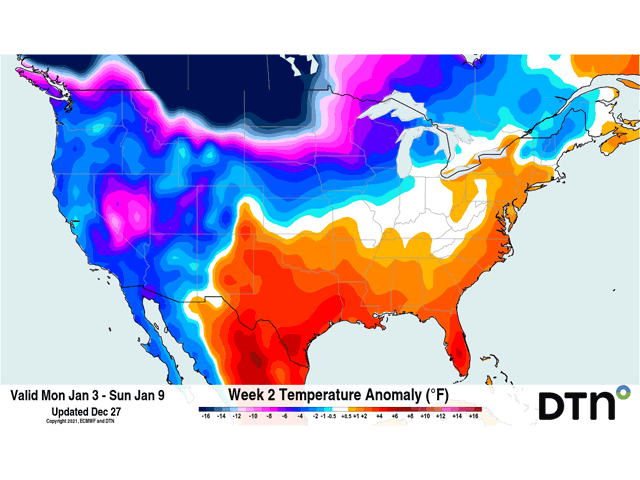
A smaller disturbance residing over the Arctic, just north of Yukon, Canada will combine with a disturbance that will move over the top of the ridge in the North Pacific and both will deepen a large lobe of the polar vortex as it moves south along the North American coastline. The connection to Alaska and northwest Canada will be maintained and cold temperatures will drain southward through Western Canada early next week as the trough moves inland and pushes the ridge out of the way. The result will be more widespread colder conditions throughout Canada and across the northern U.S. It is likely that a system will push those lower temperatures south through the Plains and middle of the U.S. in the middle or end of next week.
However, there is a caveat. Earlier model runs of the American GFS model kept the ridge across the middle of the continent rather strong, keeping the vortex back across western North America. It has only recently trended toward the European model's solution of bringing the cold air into the middle of the continent. Should the GFS and European trend back toward a stronger ridge next week, that would result in a vastly different forecast. But since the trends are toward the colder solution, I feel more confident in a colder scenario across large portions of the country next week. The only areas that may escape could be in the Southeast, where there will still be some semblance of a ridge, and the northeast, where the vortex is currently forecast to only have a passing glance.
This pattern that has set up has been a typical feature of La Nina. The North-Central U.S. and Western Canada see significant arctic intrusions, while the southern U.S. remains above normal. Meanwhile, the middle of the U.S. sees a good number of storm systems, leading to increased precipitation across the Eastern U.S. Corn Belt. La Nina is here and it is influencing our weather patterns in North America.
The big question from last week still remains -- how long does this last? Long-range models are still predicting a large warmup for much of the U.S. toward the end of January. It is just a question of how long will the cold last before the warmup comes. For those in the Canadian Prairies, it might be a long wait for warmer weather. Models are consistent in keeping lower temperatures across the region for much of the winter. There may be some breaks in that, but the cold should win out.
John Baranick can be reached at john.baranick@dtn.com
(c) Copyright 2021 DTN, LLC. All rights reserved.


Comments
To comment, please Log In or Join our Community .