

South America Calling
Very Early Wet Weather for Central Brazil

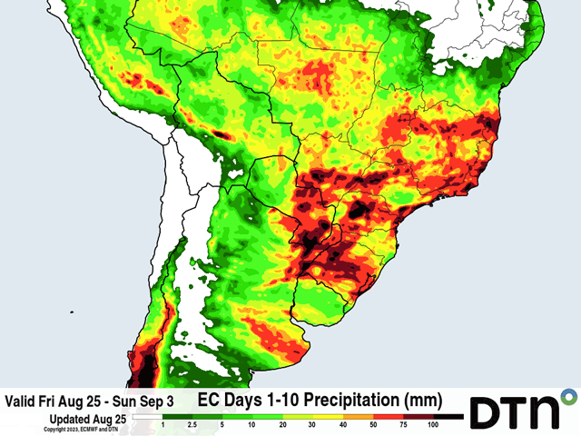
The start to the annual wet season in central Brazil is about a month away. On average, the state of Mato Grosso, Brazil's largest production state for both corn and soybeans, sees its first 30 millimeters (1.2 inches) of rainfall in the last few days of September. But if the European ECMWF model is close to being correct, that will occur during the next week, well ahead of normal.
A strong cold front in southern Brazil will push into central states this weekend and stall. Model forecasts vary, but project a high likelihood of scattered showers from Mato Grosso to Minas Gerais through at least early next week. The European ECMWF model has much more widespread and heavy rainfall than the American GFS, though. The ECMWF has daily showers through the end of its run on Sept. 3. During that time frame, widespread amounts of 25 to 75 mm (about 1 to 3 inches) are forecast over all of Brazil's agricultural areas, and especially from Mato Grosso to Minas Gerais.
During the same period, the GFS has much spottier rainfall and largely less than 25 mm for all but the state of Minas Gerais, where rainfall would be more in line with the ECMWF. Rainfall is also mostly through Aug. 31 with drier conditions afterward on the GFS. These two models have significant differences in the amounts and timing of the rain, and that will be important to work out. But either way, rainfall is coming to central Brazil well ahead of normal.
P[L1] D[0x0] M[300x250] OOP[F] ADUNIT[] T[]
The rain will help to condition soils after a long dry season of almost complete dryness since early May and some areas even longer.
If rains turn out to be closer to the ECMWF forecast, good soil conditions may tempt producers to plant earlier than normal. Many often wait for the first 30-50 mm (1.2-2 inches) of rainfall to begin planting. If these rains are realized, it could mobilize equipment early. However, some areas are going to be restricted. For those that plant soybeans before corn in this region, which is the majority of farmers, planting is illegal prior to Sept. 10 or 15, depending on the state.
However, this year, those in the state of Mato Grosso got a waiver to plant early, on Sept. 1. That earlier planting window may coincide with the better rainfall as well. A quicker start to soybean planting in the spring leads to a greater window for safrinha (second-season) corn planting in the late summer, an advantage that producers in the country would certainly welcome after La Nina restricted those windows in two out of the last three seasons.
But even if rain does occur, it will need to continue. Planting early only to have rains shut down would lead to uneven germination and early stress as temperatures routinely climb into the 30s Celsius (upper 80s to middle 90s Fahrenheit). Both extended versions of the ECMWF and GFS show a slowdown in the rains in mid-September. A forecast like that could shy producers away from planting early. But those same models also predict an on-time start to the normal wet season in late September or early October. That might get those planters rolling once the restrictions end in mid-September if the soils are already conditioned to receive the seeds. So, it will be a waiting game, but certainly one to watch.
Winter wheat has been enjoying the increased rainfall during the winter season over southern Brazil. The state of Rio Grande do Sul notes good crop conditions as the crop gets more into the reproductive and filling stages of growth. The rainfall will be helpful here as well.
The rains are not all good news if they occur, however. Late planting of last-season's safrinha corn crop meant that corn in southern Brazil still needs to be harvested before the new crop can go in. The last quarter of the corn crop in states like Mato Grosso do Sul and Parana still need to be plucked out of the fields and heavier rainfall there will continue to be a hindrance.
To find more international weather conditions and your local forecast from DTN, visit https://www.dtnpf.com/….
John Baranick can be reached at john.baranick@dtn.com
(c) Copyright 2023 DTN, LLC. All rights reserved.
Comments
To comment, please Log In or Join our Community .