

South America Calling
South America Rain Have and Have-Not
Ever since the team of Ropelewski and Halpert identified the prevailing impact of Pacific Ocean El Nino-Southern Oscillation (ENSO) events, either El Nino or La Nina, the weather trend in South America crop areas under a La Nina regime has been branded in the ag market memory. It goes like this: northern Brazil wet, southern Brazil through Argentina dry when La Nina is riding high. (The rhyme is accidental.)
And La Nina is certainly around. Pacific Ocean temperatures along the equator between South America and the International Date Line are from 1.0 to 2.5 degrees Celsius (1.8 to 4.5 degrees Fahrenheit) below normal. On the atmospheric side, the Southern Oscillation Index (SOI) catalogued by the Australia Bureau of Meteorology is solidly in La Nina territory; 30-day average SOI value was a plus 14.40, 90-day average plus 9.75 and the daily reading plus 22.26 on Dec. 22 2020.
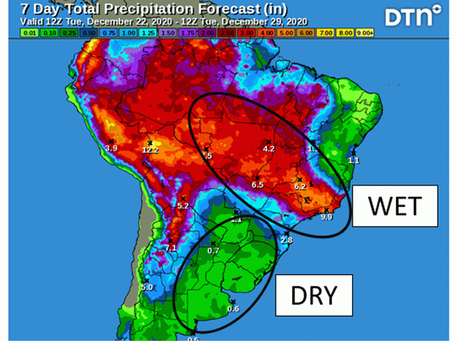
With La Nina ruling the equator sea temperature-atmospheric scene, the precipitation patterns identified by Ropelewski and Halpert are locked in. Total rainfall in northern and central Brazil through the end of December is expected to range from 2 to 6 inches. The largest row crop production state in Brazil, Mato Grosso, is in the front row for this moisture.
P[L1] D[0x0] M[300x250] OOP[F] ADUNIT[] T[]
Rainfall is already verifying; on Dec. 21 alone, rainfall in Mato Grosso was measured at more than 2.5 inches at several stations. This sector of South America is the "have" in terms of rain prospects.
In contrast, southern Brazil states of Parana and Rio Grande do Sul through the entirety of Argentina crop country have well under 1 inch of rain forecast through the end of December, generally 0.25 inch or less. Such a meager amount as the Southern Hemisphere goes into its summer season qualifies as "have not" when it comes to precipitation.
Up to this point in December, temperatures in Argentina have mostly been near to below normal. However, the end of the month has a notable warming trend. The high temperature in Cordoba, the state capital of Cordoba, is projected to hit 39 degrees Celsius or 102 Fahrenheit on Christmas Day. For this sector of South America, the description on rain prospects is "have not".
La Nina is expected to remain in effect through the rest of the South America crop year. That places this rain-no rain contrast squarely into focus as the defining feature for 2020-21.
Bryce Anderson can be reached at bryce.anderson@dtn.com
Follow him on Twitter @BAndersonDTN
(c) Copyright 2020 DTN, LLC. All rights reserved.
Comments
To comment, please Log In or Join our Community .