
Ag Weather Forum
Polar Vortex Arm Looks to Visit US, Canada Next Week
It has been a very mild start to the 2023-24 winter season as records were broken for above-normal temperatures during the month. You can read more about that here: https://www.dtnpf.com/….
But the United States and Canada are about to see a visit from the polar vortex for the first time this season, promising to bring a very dramatic shift downward in temperatures that will feel even more harsh than it otherwise would.
If the polar vortex has not been active in North America this winter, then where has it been? As is typical during December during El Nino, the polar air has been where it should be -- around the North Pole, or as was the case for much of December and early January, displaced in northern Russia. Those of us in the U.S. and Canada have had short bursts of colder air, but nothing that would be labeled as arctic just yet.
That will all change early next week, as an arm of the polar vortex is pinched off from the North Pole and settles into Western Canada by Jan. 9. Two upper-level ridges, one in Alaska, and another in the North Atlantic, will do the pinching. We have not had a dramatic ridge in either location to start the winter; this is a primary reason why we have yet to see a polar vortex event take place.
But even with the polar vortex starting to develop in Western Canada, it will take another day or two for it to pull down the air from the North Pole, with those arctic-cold anomalies below normal starting to show up on Dec. 10 in northwest Canada.
P[L1] D[0x0] M[300x250] OOP[F] ADUNIT[] T[]
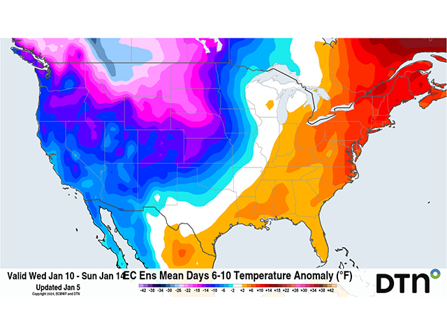
The cold will expand south and east from there into the U.S. during the following couple of days as the southern jet stream causes a few storm systems to move through the Pacific Northwest and Northern Plains Jan. 10-12. The extent and depth of the cold air are currently in question, as of Jan. 5.
Model forecasts suggest that a ridge in the Southeast may be able to contain that cold air to the western half of the U.S. and Canada, at least the harshest of the cold. That would mean from the Canadian Prairies down to the Texas Panhandle up to Missouri and Minnesota will be the areas east of the Rockies to be put into the icebox for an extended period of time.
Again, models are still working out how cold it might be, and some of that depends on the recent and forecast snow cover. A system that goes through the Plains and Midwest early in the week could lead to some very low temperature readings over the snowpack when the arctic air comes in.
You can read more about that here: https://www.dtnpf.com/…. But the snowpack in the Northern Plains and Western Canada is very low for this time of year. Bare patches exist in much of the Northern Plains and Canadian Prairies. Without the snow, the airmass will modify more quickly and be less harsh for less time. With all that said, widespread readings that fall below zero Fahrenheit (minus 18 Celsius) are likely, especially in the Canadian Prairies and Northern Plains, but also be possible in the region outlined. Temperature highs may not make it above zero F in some areas on some days.
The question will be whether or not areas to the east and south will also partake in the deep cold and also how long this event may last. The latest forecasts are less intent on bringing the harshest winter cold to the eastern Midwest or East Coast, but systems that move through the country from the abundant energy in the polar vortex could bring a little taste of the winter bite to them for brief periods.
These storms will also tend to create additional snow and may cover a lot of the U.S. The weather models keep the lid on the polar vortex (an overall ridge across Alaska, northern Canada, and Greenland) through the middle of January with a breakdown in the pattern coming around Jan. 22. That would give much of the western U.S. and especially the Canadian Prairies and Northern Plains a 10- to 14-day period of arctic air -- a long event.
It is even more of an impact when we consider how warm the start of winter has been. Drops in temperature could be on the order of 40-50 degrees F (22-28 degrees C). Cattle that are limited to the outdoors and winter grains that are uncovered by snow stand a risk of being damaged or killed by the cold. Even if cattle do not succumb, their energy inputs will be higher for feed, as will humans for heating.
During El Nino winters, visits from the polar vortex are most likely in mid-January and about four weeks later in early-to-mid-February. In between, it is usually rather warm. There are some suggestions in the long-range models and the stratosphere that another visit could be possible in that same time frame in February. That will be watched closely.
To find updated radar and analysis from DTN, head over to https://www.dtnpf.com/…
John Baranick can be reached at john.baranick@dtn.com
(c) Copyright 2024 DTN, LLC. All rights reserved.

Comments
To comment, please Log In or Join our Community .