

Ag Weather Forum
Harsh Weather Conditions for Crop Early Growth in Brazil Continue
Planting and early growth conditions in Brazil have been anything but ideal for most of the country and those same issues continue for the next seven-to-10 days.
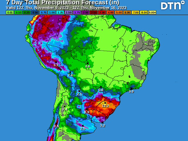
On the large scale, hot and dry conditions over central Brazil states of Mato Grosso, Mato Grosso do Sul, Goias, and even parts of Minas Gerais have led to poor germination and slowing planting conditions for soybeans during the last few weeks. Temperatures have more frequently eclipsed the 40-degree Celsius (104-degree Fahrenheit) mark than is typical. Without a regular occurrence of clouds and rain, temperatures are allowed to soar as the sun moves in right overhead.
In contrast, it has been exorbitantly wet in the southern Brazil states of Parana, Santa Caterina, and Rio Grand do Sul. Nearby areas in Paraguay and northeastern Argentina have had similar issues. Monthly records have been broken in September and October in some places, with reports of over a meter (39.4 inches) of rain during the last eight weeks. That amount of rain has obviously led to flooding problems. Reports of widespread damage due to flooding have hit the local rivers and the famed Iguazu Falls has seen its highest water levels since 2014, making it the second-highest recorded on the falls since 1977.
You can read more about the flooding on the Iguazu Falls here: https://phys.org/….
P[L1] D[0x0] M[300x250] OOP[F] ADUNIT[] T[]
Cropland is water-logged and is making it very difficult for producers there to harvest winter wheat, which has largely been damaged and seen quality drop, and plant corn and soybeans. Even if the crop is in the ground, development conditions are very poor.
After a brief break in those conditions last week and weekend, the familiar pattern has redeveloped this week. Central Brazil went dry early this week and the forecast is for that to continue through next week. Spotty, isolated showers and thunderstorms may develop, but their coverage and intensity will be well below what we typically see during the wet season. On Wednesday, thunderstorms moved back into Rio Grande do Sul from a front moving north out of Argentina. Several more of these fronts are forecast to move into the region and stall through next week, which produces more heavy rainfall for areas that do not need it.
Forecast amounts of over 75 millimeters (about 3 inches) are forecast over a wide area of the region, with locally heavier amounts being likely as well.
This pattern does show some sign of change. One of these stalled fronts over southern Brazil is forecast to shift northward into central Brazil Nov. 18-19. While southern Brazil is allowed to dry out, central and northern Brazil would get some much-needed rainfall. Whether or not this would be a temporary shift in the pattern, or a move toward a normal typical pattern of occasional rain in southern Brazil and heavier rain in central and northern Brazil remains to be seen.
But there are some indications that could be the case. Even so, the country will need some significant time in its normal pattern to right the ship for crop production in Brazil. Central Brazil's soybean crops are going to be replanted in many areas, pushing back the season and threatening the safrinha (second-season) corn and cotton crops. Soaked soils in the south will need some dry stretches to drain out and give seedlings a chance for their roots to breathe. For at least the next week, and likely longer, the weather situation in Brazil will continue to be unfavorable for crop production.
We do need to realize though that this is still very early in the season. Planting season is still upon us and the most important period for rainfall for central Brazil's soybean crop does not start for another month during pod fill. There is still time for the early-season woes to right themselves and return to a more typical pattern that would help both regions realize their record-production potential of soybeans that most agencies are still forecasting.
The corn crop, of which 75% of the annual production is due to the safrinha, is more at risk. Delays in planting, or the need for replanting, pushes back the planting of the corn crop. Now in November, that would push the crop outside of the favorable planting window, which ends in late February.
Corn planted beyond this window is at greater risk of wet season rains ending before the crop gets through its pollination period, which would cause it to rely solely on subsoil moisture to finish. So far, there is no subsoil moisture that is being built, though the wet season still has a long way to go before it ends.
To find more international weather conditions and your local forecast from DTN, visit https://www.dtnpf.com/….
John Baranick can be reached at john.baranick@dtn.com
(c) Copyright 2023 DTN, LLC. All rights reserved.

Comments
To comment, please Log In or Join our Community .