

Ag Weather Forum
El Nino Starts To Show as Southern Storm Track Starts Up Thanksgiving Week
We have been talking about it for a long time -- El Nino continues its influence on the global weather patterns. El Nino has not had the type of influence on the upper-air pattern over North America that most folks expect, but those signals are changing in the longer-range computer models.
Above-normal sea-surface temperatures in the tropical Pacific Ocean have been occurring since February off the South American Coast, slowly translating westward over the spring. The El Nino designation has been in control since May with increasing anomalies east of the Dateline during summer and fall, making it one of the strongest El Nino events on record. We have yet to see the peak in sea-surface temperatures in the Pacific Ocean, but that is expected to come in December.
El Nino has been more effective at creating disruptions in the Southern Hemisphere with typical dry conditions in Australia, a limit on the wet season rainfall in central Brazil, and heavy rain in southern Brazil.
But the effects on North America have been muted so far. When people think of El Nino, they usually expect a split in the jet stream over the Pacific Ocean. One section moves north through Canada, bringing warmer weather for the northern United States and Western Canada, while the second pieces flows across the south, creating a southern storm track that brings heavier precipitation to the southern U.S.
P[L1] D[0x0] M[300x250] OOP[F] ADUNIT[] T[]
That has not been the case so far in 2023; temperatures have been erratic this fall and drought has been building across the Four Corners area and the southeast quadrant of the country. Only the Southern Plains have been able to escape the dryness with multiple systems bringing widespread rainfall to much of Texas and Oklahoma.
We may be starting to see a shift in that upper-level pattern in some of the longer-range computer models. Starting late next week, an upper-level low is forecast to form over the Aleutian Islands. In response, the jet stream splits into two pieces, one that goes north through Canada and another, stronger piece that dives into California and shoots across the southern half of the U.S.
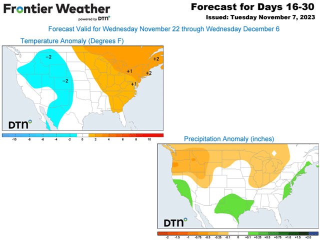
This is what we would expect to see under a strong El Nino influence. That should mean a more active southern storm track and increased precipitation for the southern tier of the country starting next weekend in the run-up to Thanksgiving, continuing into early December. The northern jet stream should keep any arctic air bottled up toward the North Pole and bring warmer conditions for the northern tier of the country.
Whether or not this pattern can be sustained is a question mark. However, history suggests that December is a very consistent month. Weak, moderate, and strong El Ninos all share similar features for the month of December. It is usually very warm for most of the U.S. outside of the Southwest where it is typically cooler, while precipitation increases are seen across the southern tier. As this feature matures in 2024, we may see the track extend even farther south, which should lead to lower precipitation in the Ohio Valley and Great Lakes, also a typical feature of El Nino. You can read more about that here: https://www.dtnpf.com/….
In December, a storm track that far south is not as evident and the DTN forecast is for near- or above-normal precipitation in this region. A very active month is forecast and intrusions of arctic air are likely to be limited or absent.
This does not mean that December will be warm every day, or that snow will not occur, but it does mean that the chances for a white Christmas are reduced for most of the country outside of the western mountains. We'll just have to see if the forecast follows the pattern, or if it deviates from it for late December. But the beginnings of the wintertime El Nino pattern for North America are now in sight.
To find more weather conditions and your local forecast from DTN, head over to https://www.dtnpf.com/…
John Baranick can be reached at john.baranick@dtn.com
(c) Copyright 2023 DTN, LLC. All rights reserved.

Comments
To comment, please Log In or Join our Community .