
Ag Weather Forum
Drought Issue Continues for Canadian Prairies

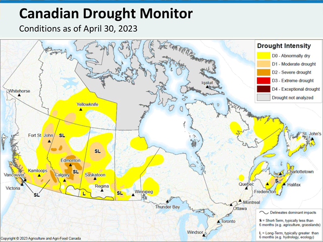
Earlier this week, the drought monitor for Canada updated and showed only minor variation from the month before. Drought improved in parts of the Canadian Prairies while degrading in others. When all is said and done, the total agricultural land in the region in some form of drought sits at 78% for the end of April, compared to 83% last month, only a slight improvement. A section of Severe Drought (D2) was indicated for western Saskatchewan through a large section of central Alberta. Thankfully, drought is not worse than the D2 classification in any part of Canada.
Though snowstorms occurred in April, especially toward the eastern Prairies, soil moisture is relatively low across the majority of the region. The areas least in drought are those found closer to the American border south of Highway 1. Precipitation had been more consistent there in recent weeks and continued into early May as well. To improve the drought situation, during the past week isolated showers have been prevalent daily across a lot of Alberta. Showers have not been overly widespread, but where they developed, they produced significant precipitation mostly in the range of 10-20 millimeters (0.4 to 0.8 inches) in total so far. In addition, rains came north out of the U.S. late this week as an upper-level system moved into the American Central Plains, covering parts of Saskatchewan and Manitoba. Rain there will continue through May 13 before a drier period takes shape.
A ridge of high pressure is developing overhead to end the week and will be a mainstay across Western Canada through the end of May. To the east, a trough will be developing across Ontario and Quebec and the two features will battle across the middle of the country for the next two weeks at least. The ridge will be the dominant player for the region, keeping temperatures above normal and likely well-above normal. Daytime highs in the 20s Celsius (lower 70s to middle 80s Fahrenheit) are going to be very common and some potential exists to get temperatures to eclipse 30 C (86 F) on some days.
The warmth will condition soils for more widespread seeding, as it has been too cold or snow-covered to do so for most areas throughout April, and only recently started to become favorable in early May. Reports from Saskatchewan on Thursday indicated that seeding progress is well behind the average pace. As of May 8, seeding progress stood at 9%, compared to the five-year average of 23% and the slowest since 2018.
P[L1] D[0x0] M[300x250] OOP[F] ADUNIT[] T[]
As of May 2, progress in Alberta was similarly slow, at just 3% complete compared to 11% on the five-year average. However, by May 9 Alberta's crop progress was up to 24% of major crops seeded, compared to 23% on the five-year average and 26% on the 10-year average. While progress in the South in Alberta is still 16% behind the five-year average, the North West and Peace regions are ahead of average, at 22% and 33% of major crop seeding, thanks to the unseasonably warm weather.
Manitoba has yet to produce a crop report this season.
With the ridge developing and dominating the pattern, precipitation that has been popping up this week will shut down. Rain may come from a couple of frontal passages as the trough in the east tries to gain influence in the region, but the prospects for widespread rainfall are not expected.
According to the North American Drought Monitor, only some improvement to the drought is forecast across parts of the Peace region in Alberta and southwest Manitoba for the month of May, while the drier and hotter period is likely to lead to worsening drought in Alberta, and potentially some development elsewhere where rains have been less intense. Drought will continue to be an issue for the region going into the main development period in June.
To go along with the dryness and drought issues, fires have been widespread across northwestern Alberta. As of Saturday morning, there were 83 active fires, with more than 26% of them out of control, according to the Alberta Wildfire Status website, increasing the number of wildfires for the year to 443. (https://www.arcgis.com/…).
You can see more on Alberta's wildfires in DTN Staff Reporter Russ Quinn's story, "Alberta Fires Burn 1 Million Acres" at https://www.dtnpf.com/….
While some rain in these areas has helped to battle the fires in recent days, the forecast for hotter and drier conditions will lead to an increased risk of fires spreading. Those could be exacerbated by increased winds. With the core of the ridge situating itself over British Columbia, this promotes downsloping (Chinook) winds off the Rockies, a cause for stronger winds. These winds may only happen a couple of the days through the end of the month, as weather systems from farther north disturb the flow near the mountains, but remain a risk nonetheless.
To find more international weather conditions and your local forecast from DTN, head over to https://www.dtnpf.com/…
John Baranick can be reached at john.baranick@dtn.com
(c) Copyright 2023 DTN, LLC. All rights reserved.
Comments
To comment, please Log In or Join our Community .