

Ag Weather Forum
Central US is a Weather Battleground Next Week for Strong Storm Systems
After a brief cold shot last week, it got warm across the United States and most of Canada yet again. That warmth is due to a ridge of higher pressure in the upper levels of the atmosphere. Next week though, an upper-level trough of low pressure will dive into western North America, setting up a battleground in the middle of the U.S. where the two will fight it out. The way the atmosphere "fights" is by creating storm systems, and two are likely to develop there, both with major weather implications.
The trough in question is currently up near Alaska and is sending a couple of pieces of energy through the ridge through this weekend. Before the trough drops down into the western U.S. next week, it will continue to be quite warm for most of the country.
These smaller pieces of energy will create a couple of storm systems. One is currently building a low-pressure center in eastern Texas on Feb. 7 that will move northeast through the rest of the week. The system will bring some moderate to heavy rain along and south of its path, and will be just cold enough for a stripe of moderate snow from northern Missouri through Wisconsin on Feb. 9.
Though the air that follows behind the storm will be colder than the temperatures out ahead of it, most areas of the country will continue to see above-normal temperatures. Only areas across the south should see temperatures that are actually below normal for this time of year. But those temperatures will quickly be replaced by warmth again after a day or two.
P[L1] D[0x0] M[300x250] OOP[F] ADUNIT[] T[]
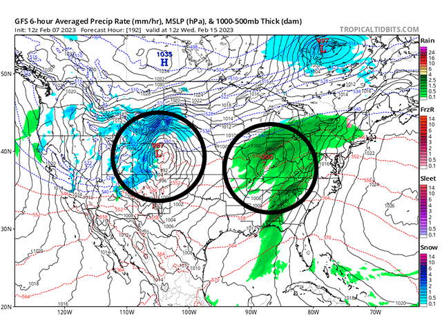
It will take the trough moving south to bring some much colder air with it. With higher temperatures already in place across the eastern half of North America, the drastic change in temperatures will fuel a pair of storm systems across the middle of the country.
The first will actually be due to one of the pieces of energy that splits away from the front and dives down the West Coast this weekend. It will move through the Four Corners area (the corners of Arizona, Colorado, New Mexico and Uah) and then northeast through the middle of the U.S. around Valentine's Day. This system will more closely mimic the current storm building in Texas, though temperatures with this system are expected to be even higher, and the threat for a band of snow developing is quite low. However, there should be enough energy for the system to produce some severe weather and another round of moderate to heavy rain. Models are still trying to figure out if this will include drought areas in the southwestern Plains or if this area again will be bypassed as so often been the case for the last calendar year. But there is some potential there.
The deep trough that pushes through western North America next week will induce another strong storm system a couple of days later. With more access to cold air from the Arctic, a band of heavier snow should be expected. Again, since this system is more than a week away from developing, models are struggling on where and how much snow may fall with this system.
The general area of interest is in the Central and Northern Plains through the Upper Midwest, a region that has seen quite a few large snowfall events thus far this winter. In fact, though in drought across much of this area, snowfall amounts and current snowpack are above normal. Some areas have already seen their typical seasonal snowfall. Cities that have reliable data like Minneapolis and St. Cloud in Minnesota, Sioux Falls and Mitchell in South Dakota, North Platte, Nebraska, Bismarck, North Dakota, and Hayward, Wisconsin have all reached or exceeded that seasonal mark already.
The southern end of the storm system should be ripe for another round of severe weather as well, though predicting severe weather this far in advance is not generally reasonable until the system becomes much more defined next week and we can see the impact the first storm may have on the second.
If the current track holds up, the second storm system would likely miss much of the Plains, though some strong winds could cause other impacts for soil moisture losses and wildfires.
The other thing to mention is this second storm should come with a sweep of cold air across the country. Models do suggest that this will be brief, but could be potent, especially for areas with fresh snowfall in the north.
Next week's weather pattern will be quite busy and have lots of folks checking on the forecast. But the following week may provide a similarly busy week. While the trough causing all the weather next week will move eastward and out of the continent by Feb. 19, another is forecast to build over Western Canada the following week. It will likely turn the Canadian Prairies and Northern Plains cold, and we will have to see just how far south that cold will penetrate into the U.S. to close out the last week of meteorological winter.
To find updated radar and analysis from DTN, head over to https://www.dtnpf.com/…
John Baranick can be reached at john.baranick@dtn.com
(c) Copyright 2023 DTN, LLC. All rights reserved.

Comments
To comment, please Log In or Join our Community .