

Ag Weather Forum
Pattern Change Coming, But Will Take Time

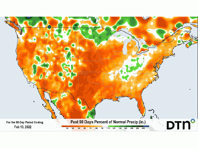
Unless you live in the Canadian Prairies or near the Canadian border, you've probably wondered where the winter snowfall has been. There have been some events here and there that have been whoppers, but nothing that has been screaming above-normal snowfall by any means.
You can point to La Nina and the clipper pattern it favors as the primary reason why precipitation and snowfall has been lacking across a wide area of North America.
Snowpack is very limited for this time of year. It is absent over much of the Northern Plains through the southern Midwest, where we usually see at least some snow on the ground for this time of year. In fact, unless you are looking at the mountains, the only areas with significant snow cover are from eastern North Dakota through the Great Lakes and into the Northeast. And the only areas that are near average for this time of year are in the Northwoods of Minnesota, Wisconsin, and the Upper Peninsula of Michigan. Even the areas in central Illinois to northern Indiana that received around a foot of snow two weeks ago have seen their snowpack dwindle to almost nothing.
The current snowpack falls perfectly into the region we would expect snowfall after the multitude of clipper systems that have moved through. This region is certainly favored. But the Plains, which have been in drought for quite some time depending on the location, are in desperate need for a pattern change that would bring bigger precipitation events before winter wheat wakes up from dormancy in the south or is sown farther north.
P[L1] D[0x0] M[300x250] OOP[F] ADUNIT[] T[]
With a ridge firmly planted in the Eastern Pacific Ocean just offshore or sometimes covering the western states and Western Canada, we have not been able to totally shake the clipper pattern. A couple of storm systems have either found weaknesses in the ridge or have plowed through it. Otherwise, the clipper pattern has stayed intact.
But models have been pointing toward that pattern change that would favor at least a couple of storm systems to take more of a "hooker" track. That is colloquially termed by meteorologists for storm systems that dig into the West, exit the Rockies into the Central or Southern Plains, and "hook" northeast into the Great Lakes. If they can appropriately tap into some of the moisture from the Gulf of Mexico, and they often do, then a band of heavy snow can form on the northern side of the track, typically from the Central High Plains to the western Great Lakes.
A system two weeks ago took a track similar to that described. Another this week is going to do the same as it moves from the Southern Plains into the Northeast Feb. 16-18. But the system will not be as wound up as a hooker system, instead staying rather flat and keeping heavy precipitation out of the Central Plains into the western Midwest, similar to the one two weeks ago.
We need to see strong troughs digging into the western states and then developing a low at its base as it moves into the Plains. We really have not seen that so far this winter. Longer range versions of the American Global Forecast System (GFS) and European Center for Medium-Range Weather Forecasting (ECMWF) are trying to point toward troughs digging into western North America by the beginning of March. Getting to that point, though, is going to take some time and the GFS and ECMWF differ on how to get there. That is totally understandable, pattern changes can differ in timing and magnitude so the differences we are seeing are not surprising.
For next week, we are going to start to see the seeds of change. While the Eastern Pacific ridge may not completely leave, it is forecast to retrograde westward closer to the Bering Sea. That opens the door for cold troughs to dig down into western North America and allow a warm ridge to develop over the Southeast. That gets us out of the clipper pattern, sets the storm track farther south, and gives chances for heavier precipitation at least for some time to the Plains and Upper Midwest, and heavier rain and thunderstorms to the Delta and eastern Midwest.
This pattern seems to be coming. Whether or not it makes for drought-busting precipitation in the Plains that need it, or just delays the growth of the drought is questionable. But it will at least provide some opportunity to those in the Plains begging for precipitation to get something more meaningful than what they have seen during the last few months.
Wanting to know more about the long-range forecast? I will be at the Louisville National Farm Machinery Show this week, discussing the long-range outlook through the 2022 growing season. If you are in town for the show, stop by the DTN booth and say hello! I would love to meet with you and learn about your farming operations.
To find more regional weather conditions and your local forecast from DTN, head over to https://www.dtnpf.com/…
John Baranick can be reached at john.baranick@dtn.com
(c) Copyright 2022 DTN, LLC. All rights reserved.
Comments
To comment, please Log In or Join our Community .