

Ag Weather Forum
Active Northern US Storm Track
Meteorological winter starts tomorrow, Dec. 1. Why the first day of December instead of on the winter solstice? Well, since the date of the solstice changes between Dec. 21 and 22 each year, it makes it much simpler just to use the first.
Us meteorologists like to make things simpler when we can; we do not get much of an opportunity with a complicated endeavor that is weather.
The last month of fall, November, has been quite an up-and-down month. The pattern has mostly been a progressive one, whereby storm systems pass quickly and freely through the country, it does not stay hot or cold for any significant length of time, and there are several precipitation events, though usually lighter.
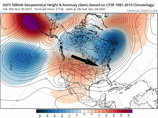
That has changed somewhat for the very tail-end of the month. A ridge of high pressure has set up in the Western U.S. while a trough has built into the Eastern U.S. That pattern leads to warm and dry weather under the ridge in the West, and typically cooler and sometimes wetter weather under the trough in the East.
P[L1] D[0x0] M[300x250] OOP[F] ADUNIT[] T[]
Between the two systems, disturbances freely flow through, which just so happens to be the case during the next week or more. This sets up a bunch of Alberta clipper-type storm systems. They are quick-moving, usually produce a band of limited but sometimes intense precipitation, occur with strong winds, and are followed by cold air from Canada. Well, these storm systems are going to be a little different.
They are not going to have a large pool of cold air in which to tap into. Temperatures in Alberta, Canada are currently in the 20s Fahrenheit on the morning of Nov. 30. However, much lower temperatures lurk farther north, where they are well-below zero. But the systems are coming with such rapid succession, they do not have the ability to bring much of the cold air with them before the next one in the series takes its place. This should keep the colder air close to the pole for the next week.
The lack of cold air changes the dynamics of the storm systems. The difference between warm and cold drives a lot of the upward motion. If there is not a strong difference in temperatures, then the upward motion is limited and the precipitation is lighter. That is what we will see on this series of storms.
That is, until we get to the weekend. After the series of storm systems slowly pushes colder air southward through Canada, a system is set up to move a little further south than the previous ones. Instead of just following the jet stream pattern between the ridge and the trough, this one will be a little stronger and slightly change the alignment. That will allow for a little more cold air to drip southward and the strength of the system will increase, bringing a bit more widespread precipitation. That will cause some showers to develop over the southeastern Plains and Delta regions as well.
However, showers are not expected to fall in the southwestern Plains, where drought has been increasing over the last couple of months. Winter wheat development in these areas has been struggling, with winter wheat ratings the second-lowest since 2010, according to DTN Lead Analyst Todd Hultman.
This is indicative of La Nina, where the Central and Southern Plains typically end up drier over the course of the winter and early spring. Now that we are heading into the cold season, we will need to keep an eye on precipitation over this region. Drier conditions through the winter and into early spring will not be favorable to a crop that is entering dormancy in poor condition.
**
Get a full rundown on the 2022 outlook for weather affecting U.S. and international crop areas during the DTN Ag Summit, Dec. 5-7, in Chicago. Visit www.dtn.com/agsummit for more details about the summit and to register.
John Baranick can be reached at john.baranick@dtn.com
(c) Copyright 2021 DTN, LLC. All rights reserved.
Comments
To comment, please Log In or Join our Community .