

Ag Weather Forum
Active Pattern Into December Showing Few Positive Signs for Winter Wheat
Active patterns typically bring several storm systems through a region that produce good rainfall. But that is not always the case. If the systems are moving too quickly, they do not develop conveyors of moisture from the Pacific Ocean or Gulf of Mexico to aid in precipitation development. Instead, what we see is a large swing of temperatures and cloudy days. Such is the case for the next week.
Large systems build up when something comes into the jet stream to create a block. Like a boulder in a stream, disturbing the flow can lead to eddies. These eddies in the atmosphere are storm systems. Larger blocks typically create larger storms and slower moving ones. The boulder in the stream also slows the flow of the water near it.
But looking at the atmosphere around North America, it is hard to find a stable piece of blocking ridge until we enter the week of Thanksgiving. We will see two areas of blocking high pressure that week. One will be near Greenland, and the other will be near the West Coast. That will induce a deep storm system across the eastern half of the country early next week. But then the blocking is expected to weaken and a return to a more active and progressive pattern can be expected going into December.
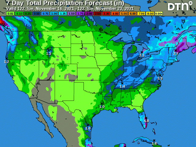
That pattern during the next week is going to bring some precipitation as these fronts move through, but mostly just to eastern areas of the country, particularly in the eastern Midwest and Delta regions. The lack of a pool of moisture is going to be limiting for precipitation across the Plains and Upper Midwest. The fronts should pick up some better moisture from the Gulf of Mexico as they head east. But even that is not a given.
P[L1] D[0x0] M[300x250] OOP[F] ADUNIT[] T[]
A front is moving through the Northern Plains on Nov. 16. It will continue to push southeast through the country through Nov. 18. Models are pretty consistent on leaving the system dry until it gets into the eastern Midwest and Delta Nov. 17, leaving the Plains mostly dry. Another system is forecast to come together this coming weekend. It appears that this one, too, will be almost devoid of moisture until it gets to the Mississippi River. Even then, models are mixed on whether or not the system will produce any meaningful showers until it reaches the East Coast and is influenced by the blocking high that sets up near Greenland.
That is going to leave the Southern Plains winter wheat areas with little to no precipitation for at least the next week. Eastern areas of the Plains have been seeing showers this fall and there is only a pocket of drought in eastern Texas with some scattered dryness in eastern Oklahoma on the latest drought monitor.
But across the west, soil moisture has been plummeting and drought has been increasing, especially in West Texas. Winter wheat conditions here are quite poor with only 24% good-to-excellent ratings in the state according to the latest Crop Progress Report from the USDA. Meanwhile, poor-to-very poor conditions are sitting at 38%.
But there is some hope. As the pattern unwinds and turns more progressive again during the week of the Thanksgiving holiday, models are pointing to a potential storm system to develop in the Southern Plains and move northeast through the Midwest right around Thanksgiving Day.
This would bring potential beneficial precipitation to the areas that need it most.
However, this system is currently about eight days out. And, with an active pattern, models typically have a harder time grabbing onto systems accurately since they are not driven as much by large-scale influences. That is causing some good variability in the models.
But at least it is something to hold on to for producers in this area as they struggle with decreasing soil moisture ahead of winter dormancy. Winter is not forecast to be kind to the Southern Plains, as warm and dry conditions are typical for La Nina winters.
**
Get a full rundown on the 2022 outlook for weather affecting U.S. and international crop areas during the DTN Ag Summit, Dec. 5-7, in Chicago. Visit www.dtn.com/agsummit for more details about the summit and to register. Register before Nov. 26 for the early bird rate.
John Baranick can be reached at john.baranick@dtn.com
(c) Copyright 2021 DTN, LLC. All rights reserved.

Comments
To comment, please Log In or Join our Community .