
South America Calling
La Nina Pattern Re-Establishing Over Argentina
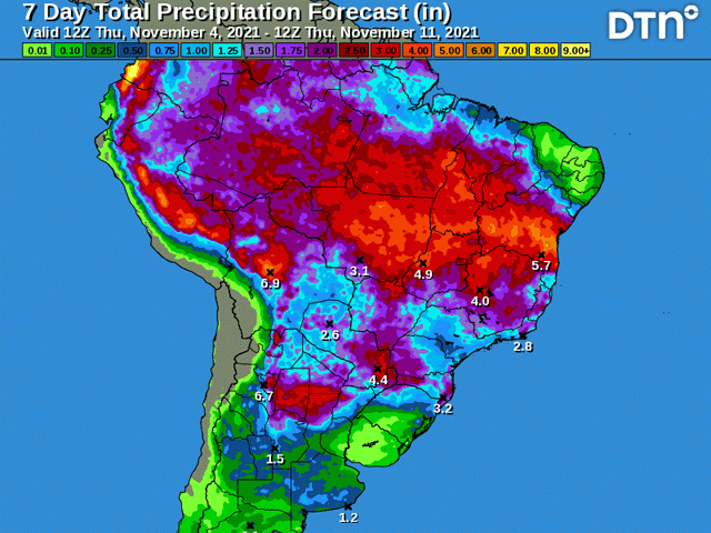
Argentina got a much-needed break in the pattern during the last week. Since Oct. 29, a good portion of the country has received at least 50 millimeters (2 inches) of rainfall with isolated areas being estimated to have received over 75 mm (3 inches). There have been a couple of areas that have not seen the good rainfall, but those have been few and far between.
The pattern is not over yet, but it is coming to a close. A frontal boundary that is currently found across Buenos Aires and La Pampa on Nov. 4 will move northward through the country and into southern Brazil through Nov. 7 before washing out. The front will still carry widespread showers through the country. Northern zones, which have had the least amount of precipitation during this pattern, are set to receive the most out of the rains with another 25 to 75 mm (1 to 3 inches) are forecast.
The country has really needed the rain. Rainfall deficits across the country have been up to 75 mm (3 inches) since the beginning of October. Early planted corn has desperately needed rains for early growth and this will help out quite a bit. But it is only one week's worth of good rainfall. The country will need much more to come out with a good season.
P[L1] D[0x0] M[300x250] OOP[F] ADUNIT[] T[]
Planting progress has slowed down dramatically due to the dryness. Argentina producers plant their corn in two stages -- one early period in September and October, and the other in November and December. The strategy takes some of the risk out of dry stretches, which is a common occurrence in Argentina, from messing with the entire crop and only affecting part of it.
So far, that early planted crop has not had good conditions. Producers have likely seen the dryness coming and are more focused on planting later, like in the La Nina-plagued season of 2020-2021. Corn planting in Argentina is just under 28% complete, which is slightly behind last year's pace of 29% and behind the average pace of almost 36% complete. Heavily weighting the summer prospects as opposed to spring is risky, but it may turn out better this year, like it did last year.
The front that sweeps through over the next couple of days will bring about a drier period back into the country. Complete dryness is likely for the weekend, but models are producing more showers next week, though in much more isolated fashion than we have seen recently. The isolated showers will create more have-nots than haves, but for some producers down south, at least it will not be completely dry, like La Nina typically does.
The pattern also includes Brazil's most southern state of Rio Grande do Sul, and similar conditions to Argentina have been felt here recently as well, though not to the same extent. Rainfall patterns over this state have been more generous, but only relatively. The state is still behind in rainfall for the season for most areas, though soil moisture is still sitting in good shape for now. A return to a drier pattern is not going to be beneficial for this state's corn and soybeans.
But for the rest of Brazil, the beneficial pattern that has developed during the last month looks to continue its good coverage and intensity of rainfall for another week. Areas around Mato Grosso do Sul and Sao Paulo would beg to differ, as it is this small portion of the country that has had less intense and widespread precipitation than either farther north or south this season, but as the front moves north from Argentina this weekend, there should be renewed daily chances for showers into much of next week.
La Nina continues to rear its ugly head for South America's weather over the next few months. Latest sea-surface temperatures in the Equatorial Pacific indicate further cooling from normal, or a strengthening event. A return to a drier stretch is likely for Argentina and far southern Brazil. And it should come as a reminder that even in an overall dry pattern, there are inevitably some days or stretches of good rainfall, much like we have seen during the last week.
John Baranick can be reached at john.baranick@dtn.com
(c) Copyright 2021 DTN, LLC. All rights reserved.

Comments
To comment, please Log In or Join our Community .