

Ag Weather Forum
December Starting Warmer, Stormier
Though it got cold behind a strong cold front for the Thanksgiving holiday into this week, those temperatures are temporary. The upper-level trough responsible for the cold will be moving off the East Coast on Wednesday, though the northern piece of it will strengthen in Hudson Bay for a few days.
In its place, the pattern will become quite active going into early December with a couple of disturbances and troughs moving across the U.S. through early next week.
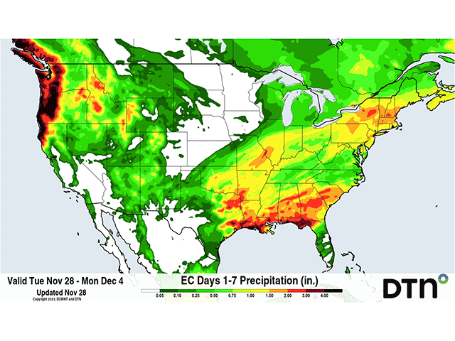
That should spark a couple of storm systems and indeed, about two are forecast. The first comes to the Southern Plains on Thursday, developing over Texas and Oklahoma, then following the Ohio River into the Northeast on Friday. Widespread showers are forecast along the low path down to the Gulf of Mexico. The system will likely leave a front behind in the Southeast with additional showers for early Saturday.
Another system will move into the Southern Plains later on Saturday and develop another low-pressure center that will move along the Ohio River into the Northeast Sunday into Monday on a similar path to the first. More widespread showers are forecast with this system and there is potential for this one to be stronger than the first.
P[L1] D[0x0] M[300x250] OOP[F] ADUNIT[] T[]
The widespread rainfall will be helpful for those experiencing extreme or exceptional drought from Louisiana through the Tennessee Valley. Some limited benefits to the ongoing drought in the Midwest will be possible as well. More importantly, the precipitation will be of major benefit to the water levels on the Mississippi River. Recently, precipitation has increased the water levels near the low-water mark on several locations from Cairo southward, but the river is still running very low and needs more water to flow through to bring levels up near normal. The coming rain will be helpful.
With both systems coming during December, we must address the potential for snow. In that regard, the Hudson Bay trough will be important. As it dissolves this weekend, the access to cold, Canadian air will shut off and the systems that move through will ingest milder, Pacific air instead. Therefore, most of the precipitation will fall as rain. There may still be enough cool air around to turn the northern edges of both systems over to snow, however. Temperatures will be borderline. Models are waffling back and forth whether or not there will be enough cold air to turn precipitation over to accumulating snow, have a mix, or just keep it rain.
Part of the reason that these models are flipping back and forth is because they do not agree on how the second system will develop. They are fairly consistent on the first, within only a slight risk of a streak of snow in the Midwest, but have differences with the second. Between the European ECMWF and American GFS, both models have disagreed on the strength of the second system and whether or not disturbances moving in from the West will phase together into a single system, or have separate impulses along the same track in quick succession this weekend into Monday.
Any separation in the disturbances would make for weaker storms and less potential to bring in enough cooler air to change over to snow. A larger storm system would be more likely to achieve those goals.
Either way, the risk for accumulating snow is currently low and limited to small areas in the Midwest, but it will be something to watch out for. Even if snow occurs, it will be coming with temperatures near or above normal for early December.
During El Nino conditions, December tends to be a very warm month outside of the Southeast U.S. On a few occasions, the North-Central and Northeast end up cooler, but that is rare. There is some indication that the end of the month could end on a cooler note, just in time for Christmas. That will be something to watch. Otherwise, expect a mostly warmer-than-normal tone for the first few weeks of the month. A more active pattern may continue as well, favoring a southern storm track that would continue to bring storm systems to the Southern Plains, shifting them either east or northeast.
To find more weather conditions and your local forecast from DTN, head over to https://www.dtnpf.com/…
John Baranick can be reached at john.baranick@dtn.com
(c) Copyright 2023 DTN, LLC. All rights reserved.

Comments
To comment, please Log In or Join our Community .