
Ag Weather Forum
Polar Vortex Setting Up to Bring Cold Weather Back to Central US, Canada
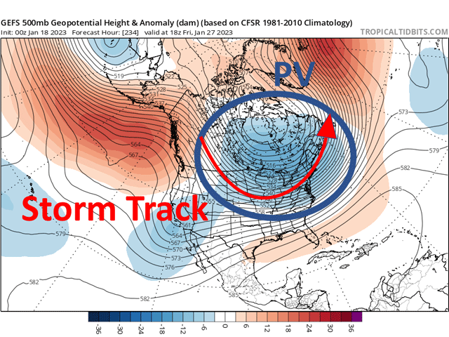
The recent pattern of a trough in the Pacific Ocean which led to heavy, drought-reducing precipitation across the West, and a broad ridge across North America is starting to change. The new pattern will be an almost complete 180-degree shift in the upper levels.
The change to a new pattern will take some time to fully be recognized and feel like winter again, but it is coming. The polar vortex will make another visit before the winter is over.
To date this year, temperatures are running well-above normal for most of North America. The pattern has been an active one with systems slamming the West Coast, and especially California, before those systems produce widespread precipitation east of the Rockies.
Some areas have been left out, namely the far northwestern Plains and Canadian Prairies, as well as the southwestern Plains. But others have seen drought reduction in January, an unusual occurrence during La Nina -- when sea-surface temperatures in the equatorial Pacific Ocean are lower than normal.
P[L1] D[0x0] M[300x250] OOP[F] ADUNIT[] T[]
We have seen some rather strong storms out of this pattern. One of them is currently moving through the middle of the U.S. Jan. 18 with a band of heavy snow in the Central Plains and Upper Midwest and chances for severe weather across Lower Mississippi River Valley. Two more systems will track a bit farther south, starting in Texas and moving along the Ohio River. One develops this weekend, while another goes through early-mid next week. Models do not agree on the development of these systems, but that is what they have been trending toward.
Farther north, clipper systems will start to pass through the Canadian Prairies and northern tier of the U.S. These systems will try to pull down colder air, but the air farther north in northwest Canada and toward the North Pole is not very cold for this time of year.
With a pattern that will favor a trough across northern Canada next week, eventually, a pool of cold air will build and be forced south. But that will take some time. Colder shots will certainly move through, and the above-normal temperatures much of the country has been enjoying will come to an end. But it may take until the start of February until that is a consistent feature.
Models are suggesting that lasts the first seven to 10 days of February before we see a sort of retreating of the colder air more toward the northwest, but maintaining for Western Canada, the Pacific Northwest, and Northern Plains. But that is far out in the future and subject to change.
The winter is not over and the reprieve, at least in temperatures, that North America has enjoyed during the last few weeks will return to a typical La Nina state. It's one that favors clipper systems moving through the Canadian Prairies into the north-central U.S. and bringing bouts of cold, arctic air behind them. Some of these pushes could be harsh going into February, and enough to make it down into the Southeast, but that is not guaranteed.
The polar vortex will be making a visit yet again, spreading the cold, arctic air through Canada and into the U.S., but it may take a little time yet to do so. The question now is, how long does this last?
There are a few reasons to believe this pattern will continue through February and into March. One of those is the orientation of the polar vortex higher up in the stratosphere. Models suggest a warming event late this month into early February. When those events occur, cold events tend to happen a few weeks later, which would be in late February into March. If the beginning of February favors cold across Western Canada and the north-central U.S. and the late month does as well, we could see a good portion of the middle of North America staying colder through a good chunk of February.
To find updated radar and analysis from DTN, head over to https://www.dtnpf.com/…
John Baranick can be reached at john.baranick@dtn.com
(c) Copyright 2023 DTN, LLC. All rights reserved.

Comments
To comment, please Log In or Join our Community .